Pere Blasi: Situat entre 0º19′ i 3º20′, 40º32′ i 43º51′, un triangle aprox de 250km. Els límits naturals arribarien al Cinca al W (la Franja), i la Cerdanya francesa i el Rosselló, amb les valls de Conflent, Vallespir i Capcir.
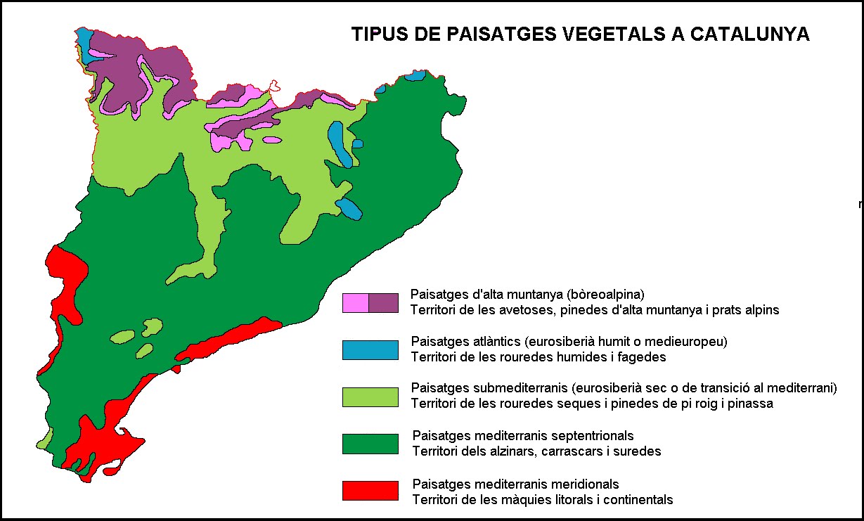
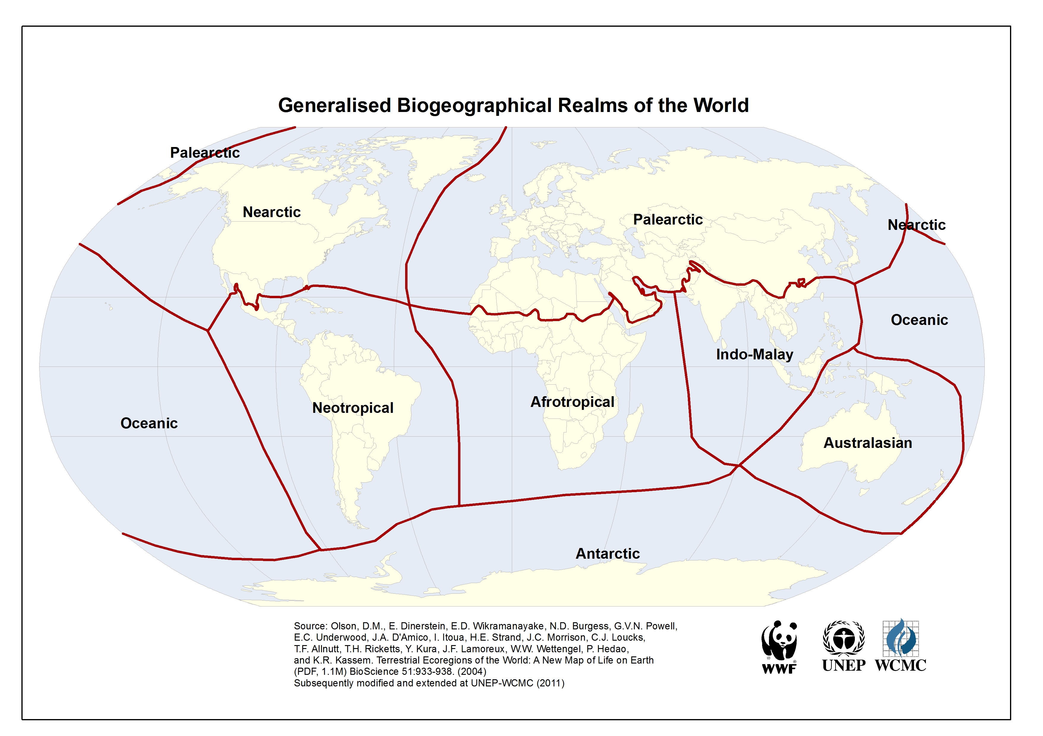
Ecoregions: Catalunya forma part del Paleartic, mediterrà i pertany a tres ecoregions:
PA0433 Pyrenees Conifer And Mixed Forests.te_bosc_caducifoli
PA1209 Iberian Sclerophyllous And Semi-Deciduous Forests.bosc_mediterrà
PA1215 Northeastern Spain And Southern France Mediterranean Forests.bosc_mediterrà
Pirineu [66Ma orogènia Alpina sobre l’herniciana]: (1) A l’oest i de Nord a sud: Maladeta (entre el Cinca i la Noguera R), massís de la Vall d’Aran i Beret, cap al sud i fins a la Noguera Ribagorçana: Montsent de Pallars, Serra sant Gervàs, (massís Torreta de l’Orri), serra de Lleres, Conca de Tremp (Pallars Jussà) i Montsec (Noguera). Rasos de Conques, serra de sant Joan, Serra Boumort (2) La Cerdanya travessada pel Segre, amb el Puigpedrós al nord i al sud el Cadí. La vall segueix a França amb la Tet, el Carlit i l’Arieja al N i al S el Cadí es prolonga de manera natural amb el Montgrony, el Puigmal, Costabona i el Canigó. (3) Al Prepirineu tenim la Serra del Port del Comte, els Rasos de Peguera, Serra de Catllaràs, Matamala. Cavallera, Capsacosta, serra Sta Magdalena. El Bassegoda a dalt de la Garrotxa, [Els Aspres i els Salines, la vall de la Jonquera] i la serra de l’Albera amb el Cap de Creus.
Serralada transversal: [origen volcànic fa uns 10 Ma] separa la depressió de l’ebre de la prelitoral [Empordà]. Serres de Milany- sant Magdalena- Puigsacalm- Bellmunt. A sota i a W de La Vall de’n Bas, el Collsacabra amb Rupit i Tavertet, i a l’est la zona volcànica d’Olot i la serra de finestres.
Depressió central de SW a NE: [Segrià, Pla d’Urgell, Urgell, Garrigues], altiplà Segarra / Conca de Barberà , Solsonès, Anoia amb Conca d’Òdena, Berguedà, Bages (pla de Bages), altiplà Lluçanes, altiplà moianès, Osona fins que es limita amb la serralada transversal (plana de Vic) i Guilleries Collsacabra. [ L’Empordà era depressió central fins que va quedar talalt per la serralada transversal?]
Depressió prelitoral: [ la serralada litoral comença al Garraf, d’orgen tectònic es va enfonsar la cadena costera catalana ] Penedès, Vallès
Costa: Delta de l’Ebre / Golf de Sant Jordi fins al cap de Salou Baix Camp/ Camp de Tarragona [Garraf] / Barcelonès [maresme] [Costa Brava] Empordà Golf de roses [cap de creus]
Els Ports de Beseit són el final de la serra d’Albarracin del sistema ibèric [ 30Ma igual que la cadena costera catalana]
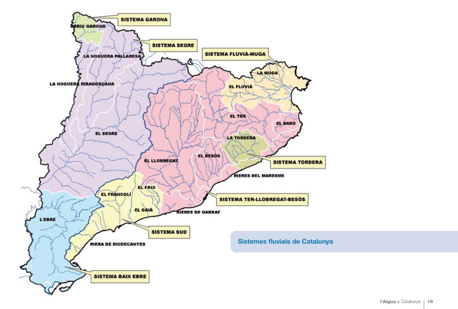
CONQUES HIDROGRÀFIQUES
Nord: la Muga neix als Aspres, embassament de Boadella, travessa l’Empordà, passa per Castelló d’Empúries i desemboca a Empúries. El Fluvià neix a la Garrotxa, travessa la plana de’n Bas, Olot, Castellfollit, Besalú i desemboca al golf de Roses, prop de Sant Pere Pescador.
La Tordera: Neix al Montseny entre les Agudes i el Matagalls, es desvia una mica al nord en trobar les muntanyes del Maresme i desemboca entre Blanes i Malgrat de Mar.
Sistema Ter – Llobregat – Besós
El Ter: 208km, neix a UlldeTer al Pirineu, Camprodon, Sant Joan de les Abadesses, Ripoll on rep el Freser, Sant Quirze de Besora, Torelló, Manlleu, embassament de Sau, Girona on rep l’Onyar, Torroella de Montgrí i desemboca entre Pals i l’Estartit. El Daró neix a les Gavarres, passa per la Bisbal i a Gualta es divideix en un canal que acaba al Ter i sèquies que reguen els aiguamolls de Pals.
El Llobregat, neix al Berguedà, rebent aigües del Cadí i del Montgrony, embassament de Cercs, travessa la Catalunya central ( a Manresa Pere el Cerimoniós va fer construir la Sèquia). 175 km. A CastellGalí rep les aiguës del Cardener i a Martorell l’Anoia.
El Besós té 17.7 km i és format per les contribucions del Congost, el Mogent i el Ripoll. A Montcada i Reixach, el rec Comtal que havia estat un aqueducte romà]
Sistema sud: El Foix neix a la Serra d’Ancosa, a la Serralada Prelitoral al terme municipal de la Llacuna, creua la depressió prelitoral i la Serralada Litoral per desembocar al Mediterrani a Cubelles (Garraf, 41 km. ). El Gaià neix prop de Santa Coloma de Queralt, als contraforts de la Depressió Central, i recull les aigües de les serres de Brufaganya i de Serra de Queralt. Creua la Serralada Prelitoral Catalana, més concretament el Bloc del Gaià, i passa pel conjunt cistercenc del monestir de Santes Creus. Després del pantà del Catllar gairebé no te cabal Desemboca a Altafulla (59 km). El Francolí neix Vímbodi, rebent aigües de les muntanyes de Prades al sud, a Montblanc es troba amb el riu Anguera i desemboca al port de Tarragona.
Sistema Ebre: Dels Pirineus, les Nogueres que van a parar al Segre travessant el Segrià fins anar a parar a l’Ebre a Mequinensa. El Canal d’Urgell rega els camps del Segrià (144 km i 76km).
[ La sèquia a Manresa construïda per Pere III el Cerimoniós.
PLUVIOMETRIA
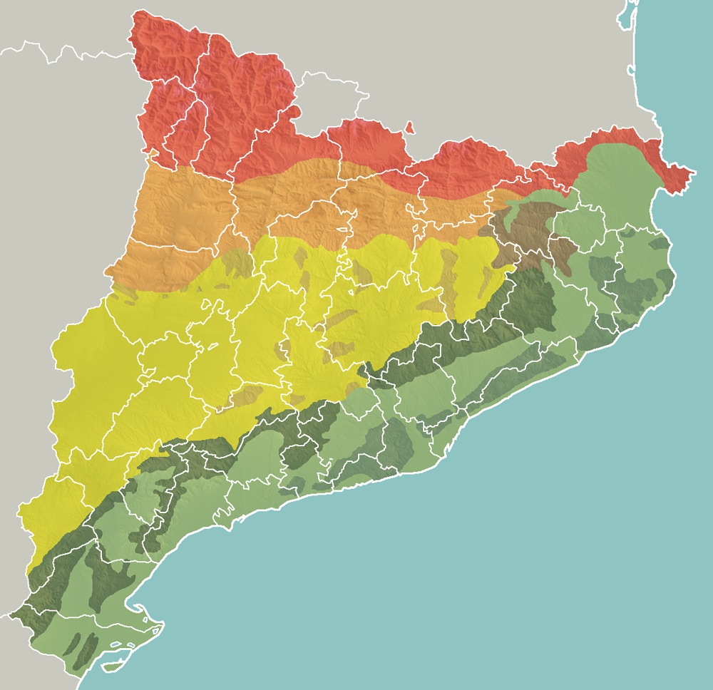
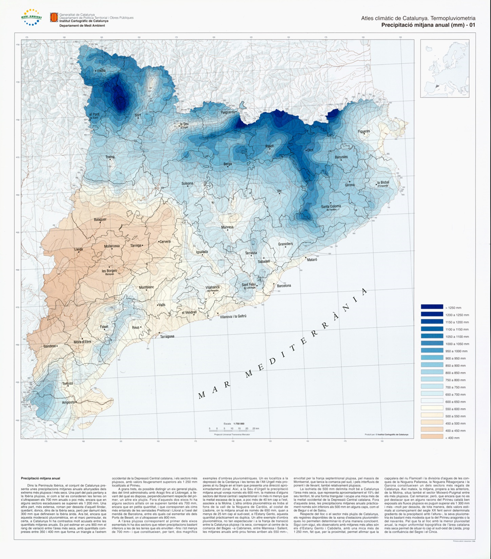
Pluviometria: gràfic, estadístiques [ 1200 mm a les zones plujoses, 400 a les seques, estimem 700mm de mitjana, que amb uns 32 103 km 2, dóna 22 10 7 m 3 de pluja ]
A l’hivern les temperatures oscil·len entre mínimes de 5º i màximes de 16, i a l’estiu, mínimes de 20º i màximes de 32º [ aproximat, les fonts o bé són massa detallades ]. Les precipitacions mitjanes són de 600mm anuals, amb uns 80mm els mesos de tardor, 50 a primavera i 30 a la resta.
Micronesia which lies north of the equator and west of the International Date Line, includes the Mariana Islands in the northwest, the Caroline Islands in the center, the Marshall Islands to the west and the islands of Kiribati in the southeast.
Melanesia to the southwest, includes New Guinea, the world’s second largest island after Greenland and by far the largest of the Pacific islands. The other main Melanesian groups from north to south are the Bismarck Archipelago, the Solomon Islands, Santa Cruz, Vanuatu, Fiji and New Caledonia.[71]
Polynesia stretching from Hawaii in the north to New Zealand in the south, also encompasses Tuvalu, Tokelau, Samoa, Tonga and the Kermadec Islands to the west, the Cook Islands, Society Islands and Austral Islands in the center, and the Marquesas Islands, Tuamotu, Mangareva Islands, and Easter Island to the east.
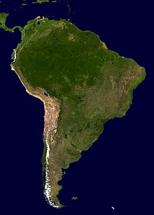
Geografia | Centre Amèrica i Caribe | Orinoco i Amazonas | Andes |
Correspon al reialme Neotropic [A grans trets és la serralada dels andes i la conca de l’Amazonas]. Els Andes es van començar a formar al Cenozoic i segueixen.
CARIBE: Cuba, Jamaica. Haiti, Puerto Rico. Boscos Tropicals i subtropicals secs i humits
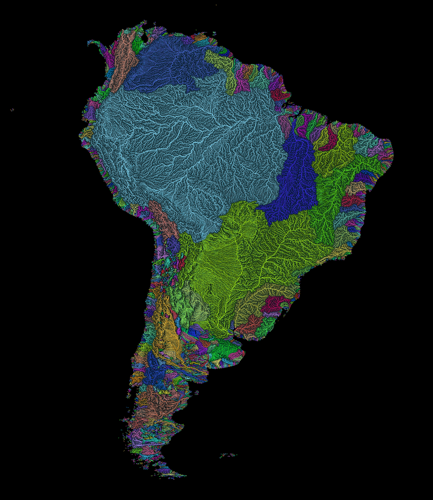
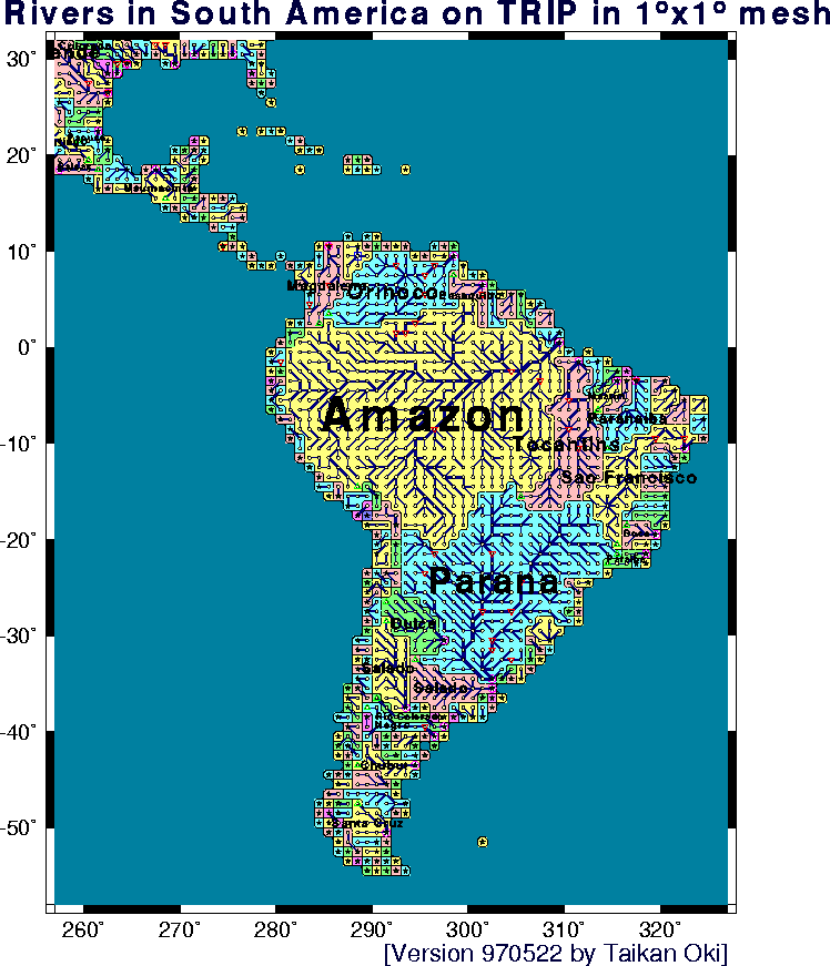
ORINOCO i AMAZONAS
The Orinoco is a region of humid forested broadleaf forest and wetland primarily comprising the drainage basin for the Orinoco River and other adjacent lowland forested areas. This region includes most of Venezuela and parts of Colombia.
Amazonia The Amazonia bioregion is mostly covered by tropical moist broadleaf forest, including the vast Amazon rainforest, which stretches from the Andes mountains to the Atlantic Ocean, and the lowland forests of the Guianas. The bioregion also includes tropical savanna and tropical dry forest ecoregions.
ELS ANDES
The Northern Andes in Venezuela, Colombia, and Ecuador: Boscos tropicals
The Central Andes in Peru and Bolivia: Boscos tropicals, desert
The Southern Andes (south of Llullaillaco) in Argentina and Chile. Mediterrani, prats de muntanya
EST
[Centre i est del Brasil) Eastern South America Eastern South America includes the Caatinga xeric shrublands of northeastern Brazil, the broad Cerrado grasslands and savannas of the Brazilian Plateau, and the Pantanal and Chaco grasslands. The diverse Atlantic forests of eastern Brazil are separated from the forests of Amazonia by the Caatinga and Cerrado, and are home to a distinct flora and fauna.
SUD
Southern South America The temperate forest ecoregions of southwestern South America, including the temperate rain forests of the Valdivian temperate rain forests and Magellanic subpolar forests ecoregions, and the Juan Fernández Islands and Desventuradas Islands, are a refuge for the ancient Antarctic flora, which includes trees like the southern beech (Nothofagus), podocarps, the alerce (Fitzroya cupressoides), and Araucaria pines like the monkey-puzzle tree (Araucaria araucana). These magnificent rainforests are endangered by extensive logging and their replacement by fast-growing non-native pines and eucalyptus.
Deserts, Estepa Patagònia, Boscos temperats de Valdivia, flora subpolar
Les Rocky Mountains s’extenen per tot l’oest, de Canadà a Mèxic, (orogènia laramy 80-55ma) i les Appalachian Mountains a l’est (orogènia caledonia 490-390 Ma).
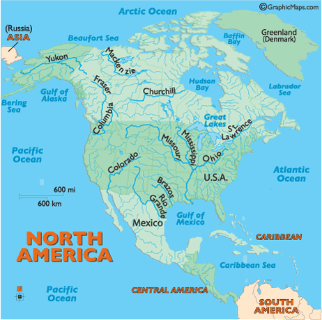
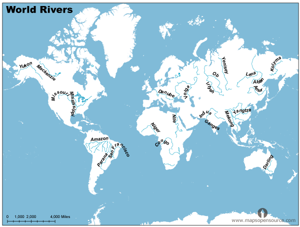
Els principals rius són el Yukon, Mackenzie a Alaska, el Mississipi i Missouri al centre, el Colorado i el Río Grande que limita amb Mèxic.
The Canadian Shield bioregion (55 a 70º latitud) extends across the northern portion of the continent, from the Aleutian Islands to Newfoundland. It includes the Nearctic’s Arctic Tundra and Boreal forest ecoregions. In terms of floristic provinces, it is represented by part of the Canadian Province of the Circumboreal Region.
The Eastern North America bioregion includes the temperate broadleaf and mixed forests of the Eastern United States and southeastern Canada, the Great Plains temperate grasslands of the Central United States and south-central Canada, the temperate coniferous forests of the Southeastern United States, including Central Florida. In terms of floristic provinces, it is represented by the North American Atlantic Region and part of the Canadian Province of the Circumboreal Region.
The Western North America bioregion includes the temperate coniferous forests of the coastal and mountain regions of southern Alaska, western Canada, and the Western United States from the Pacific Coast and Northern California to the Rocky Mountains, as well as the cold-winter intermountain deserts and xeric shrublands and temperate grasslands and shrublands of the Western United States. In terms of floristic provinces, it is represented by the Rocky Mountain region.
Northern Mexico and Southwestern North America. The Northern Mexico bioregion includes the mild-winter to cold-winter deserts and xeric shrublands of northern Mexico, Southern California, and the Southwestern United States, including the Chihuahuan, Sonoran, and Mojave Deserts. The Mediterranean climate ecoregions of the Southern and Central Coast of California include the California chaparral and woodlands, California coastal sage and chaparral, California interior chaparral and woodlands, and California montane chaparral and woodlands. The bioregion also includes the warm temperate and subtropical pine and pine-oak forests, including the Arizona Mountains forests and the Sierra Madre Occidental, Sierra Madre Oriental, and Sierra Juarez and San Pedro Martir pine-oak forests.
[ Del punt de vista de les ecoregions, el mediterrà i els deserts formen part del Paleartic, juntament amb Europa, Rússia, Orient mitjà i Xina]
[Mediterrà i conca del Nil]: Clima mediterrani costa nord, muntanyes de l’Atlas, conca del Nil, prats inundats.
Sahara and Arabian deserts. Deserts: de la latitud 35 fins a 15, uns 2000 km. A great belt of deserts, including the Atlantic coastal desert, Sahara desert, and Arabian desert, separates the Palearctic and Afrotropic ecoregions. This scheme includes these desert ecoregions in the palearctic realm; other biogeographers identify the realm boundary as the transition zone between the desert ecoregions and the Mediterranean basin ecoregions to the north, which places the deserts in the Afrotropic, while others place the boundary through the middle of the desert.]
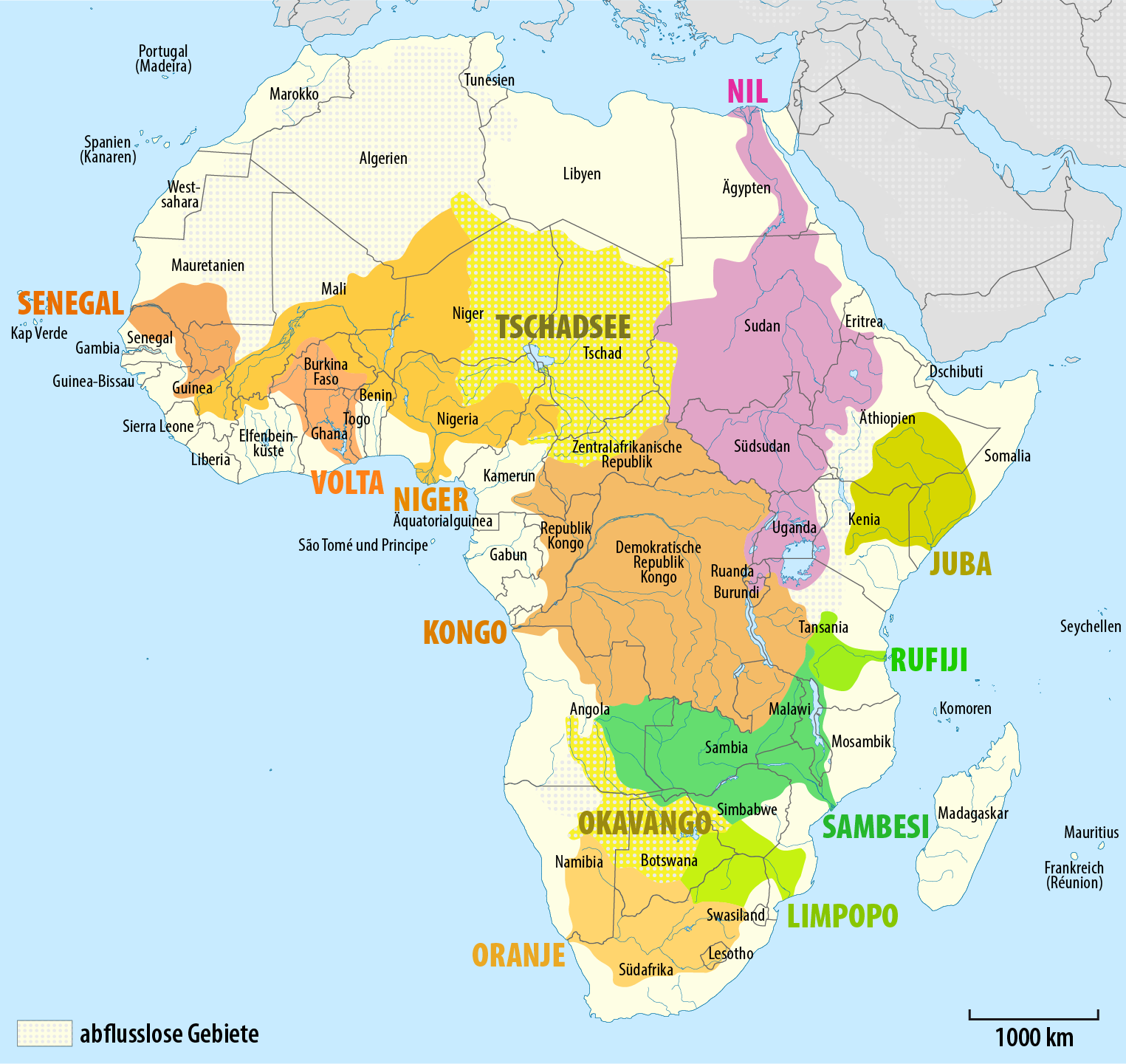
El reialme Afrotropical és dividit en 8 zones, una de la península aràbiga que es veu a Orient mitjà)
Sahel and Sudan. Franja semiàrida al voltant de 15º latitud. Savana d’acàcia. [Travessada pels rius Senegal, Níger i alt Nil]. South of the Sahara, two belts of tropical grassland and savanna run east and west across the continent, from the Atlantic Ocean to the Ethiopian Highlands. Immediately south of the Sahara lies the Sahel belt, a transitional zone of semi-arid short grassland and acacia savanna. Rainfall increases further south in the Sudanian Savanna, also known simply as the Sudan, a belt of taller grasslands and savannas. The Sudanian Savanna is home to two great flooded grasslands, the Sudd wetland in South Sudan, and the Niger Inland Delta in Mali. The forest-savanna mosaic is a transitional zone between the grasslands and the belt of tropical moist broadleaf forests near the equator. [Muntanyes Simien]
Boscos Tropicals. [La vall del Congo] Forest zone The forest zone, a belt of lowland tropical moist broadleaf forests, runs across most of equatorial Africa’s intertropical convergence zone. The Upper Guinean forests of West Africa extend along the coast from Guinea to Togo. The Dahomey Gap, a zone of forest-savanna mosaic that reaches to the coast, separates the Upper Guinean forests from the Lower Guinean forests, which extend along the Gulf of Guinea from eastern Benin through Cameroon and Gabon to the western Democratic Republic of the Congo. The largest tropical forest zone in Africa is the Congolian forests of the Congo Basin in Central Africa. A belt of tropical moist broadleaf forest also runs along the Indian Ocean coast, from southern Somalia to South Africa.
East African grasslands and savannas Acacia-Commiphora grasslands; Serengeti [Kenia Tanzania]
Eastern Africa’s highlands. Afromontane region, from the Ethiopian Highlands [Simien] to the Drakensberg Mountains of South Africa, including the East African Rift. Distinctive flora, including Podocarpus and Afrocarpus, as well as giant Lobelias and Senecios. Ethiopian Highlands; Albertine rift montane forests; East African montane forests and Eastern Arc forests
Southern African woodlands, savannas, and grasslands Miombo woodlands; Zambezian mopane and Baikiaea woodlands; Bushveld
Deserts of southern Africa Namib Desert; Kalahari Desert; Karoo; Tankwa Karoo; Richtersveld. EL riu Okavango va des d’Angola fins a un delta al desert de Kalahari. EL ambeze desemboca a l’ïndic. El riu Orange travessa sudàfrica per acabar a l’Atlàntic.
Cape floristic region The Cape floristic region, at Africa’s southern tip, is a Mediterranean climate region that is home to a significant number of endemic taxa, as well as to plant families like the proteas (Proteaceae) that are also found in the Australasian realm
Madagascar and the Indian Ocean islands Madagascar and neighboring islands form a distinctive sub-region of the realm, with numerous endemic taxa like the lemurs. Madagascar and the Seychelles are old pieces of the ancient supercontinent of Gondwana, and broke away from Africa millions of years ago. Other Indian Ocean islands, like the Comoros and Mascarene Islands, are volcanic islands that formed more recently. Madagascar contains several important biospheres, as its biodiversity and ratio of endemicism is extremely high.
Australasia comprises Australia, New Zealand, the island of New Guinea, and neighbouring islands in the Pacific Ocean. Most of Australasia lies on the southern portion of the Indo-Australian Plate, flanked by the Indian Ocean to the west and the Southern Ocean to the south.[73] The bulk of Australasia sits on the Indo-Australian Plate, together with India.
PAPUA NOVA GUINEA
Boscos tropicals humits
AUSTRÀLIA
Northern Territory: Sabana tropical
Western Australia: Altiplà, clima mediterrà a la costa i desert a l’interior. A l’est té el Great Victoria Desert.
The Eastern Highlands: Great Dividing Range, amb boscos de caducifolis emperats a l’estreta franja de la costa i savana tropical i subtropical a les muntanyes. A uns 100 km de la costa hi ha la Great Barrier Reef.
Al sud hi ha la conca dels rius Murray i Darling. Clima mediterrà. Uns 100 km més al sud la illa de Tasmania.
[ Juntament amb la Índia Indoxina i l’arxipèlag de malaisia forma el reailme Indo-malai.
The Indochina bioregion includes most of mainland Southeast Asia, including Myanmar, Thailand, Laos, Vietnam, and Cambodia, as well as the subtropical forests of southern China.
Sunda shelf and the Philippines Malesia is a botanical province which straddles the boundary between Indomalaya and Australasia. It includes the Malay Peninsula and the western Indonesian islands (known as Sundaland), the Philippines, the eastern Indonesian islands, and New Guinea. While the Malesia has much in common botanically, the portions east and west of the Wallace Line differ greatly in land animal species; Sundaland shares its fauna with mainland Asia, while terrestrial fauna on the islands east of the Wallace line are derived at least in part from species of Australian origin, such as marsupial mammals and ratite birds.]
Indoxina
Clima tropical, calent i humit en general.
A l’oest limitant amb la Índia les muntanyes Arakan o Rakhine Mountains, i després la vall del riu Irrawaddy. Al nord les muntanyes a Chiang Mai i Luang Prabang (Laos), el clima és subtropical. El poderós Mekong travessa el centre de la península.
ARXIPÊLAG
Indonèsia: Les illes de Sumatra, Java, , Borneo i Sulawesi, . Nova Guinea i Timor es consideren part d’Austràlia geogràficament. Clima tropical, abril-octubre seca, novembre març humida
Filipines: clima Tropical, les illes principals Luzon i Mindanao
A l’oest (Pakistan) hi trobem la vall de l’Indus, que limita amb les muntanyes del Baluchistan i el desert del Thar. (Orient mitjà)
Al triangle del sud els Western and Eastern Ghats que envolten el Deccan (boscos tropicals secs, desert).
Al nord hi ha l’himalaia (i després Xina) i la vall del Ganges i les muntanyes Aravalli hills, Satpura i Vindhya . Al delta del Ganges hi arriba el riu Bramaputra (boscos subtropicals humits). A l’est hi ha les muntanyes xx de Birmània (Sudest asiàtic)
La Índia està entre le slatituds 35 i 7, amb el tròpic de càncer (latitud de 23º) que el creua. El clima és tropical i subtropical sec i humit. L’Himalaia frena vents freds de l’Àsia central. El desert del Thar atrau vents monsons carregats d’humitat a l’estiu que descarreguen fortes pluges entre juny i octubre.
[ Juntament amb àsia sudest forma el reialme indo-malaiIndian Subcontinent. The Indian Subcontinent bioregion covers most of India, Pakistan, Bangladesh, Nepal, Bhutan, and Sri Lanka. The Hindu Kush, Karakoram, Himalaya, and Patkai ranges bound the bioregion on the northwest, north, and northeast; these ranges were formed by the collision of the northward-drifting Indian subcontinent with Asia beginning 45 million years ago. The Hindu Kush, Karakoram, and Himalaya are a major biogeographic boundary between the subtropical and tropical flora and fauna of the Indian subcontinent and the temperate-climate Palearctic realm.]
geografia | Turquia, Mediterrà, Mesopotàmia, Desert d’Aràbia, Pèrsia
[ En principi Pakistan pertanyeria sencer al rialme Indomalia però les muntanyes del Baluxistan pertanyen al Paleartic, així que ho deixo fora. Aquestes muntanyes són una estribació de l’himalaia i separen actualment Afghanistan del Pakistan. La denominació actual “Orient mitjà” inclou Egipte]
Turquia: la península d’Anatòlia, entre el mar negre i el mediterrani. Amb les muntanyes Köroğlu i Pontic al nord, els Taurus al sud. A l’est les muntanyes on neixen el Tigris i l’Eufrates, el llac de Van i la muntanya Ararat. Al sudoest el clima és mediterrani. Al nord i centre, la meseta d’anatòlia amb estepa i boscos temperats. Hi ha una gran biodiversitat, aquí encara creixen en estat salvatge els precursors de la majoria de conreus.
Mediterrà: Síria Líban Israel, el riu Jordà, el mar de Galilea i el mar mort.
Mesopotàmia: Tigris Eufrates (Síria, Iraq), és tot desert, amb les franges dels rius fins que a partir de Bagdad hi ha una vall aluvial.
Desert d’Aràbia: [la costa NW està inclosa en el reialme Afrotropical: Southern Arabian woodlands. South Arabia, expressed as being mostly Yemen and parts of western Oman and southwestern Saudi Arabia, has few permanent forests. Some of the notable are Jabal Bura’, Jabal Raymah, and Jabal Badaj in the Yemeni highland escarpment, and the seasonal forests in eastern Yemen and the Dhofar region of Oman. Other woodlands scatter the land and are very small and are predominantly juniper or acacia forest]
Iran (muntanyes nord i est): Al nord el Caucas, el mar Caspi, les muntanyes Alborz, a l’oest les muntanyes Zagros limitant amb la vall de Mesopotàmia, al centre l’altiplà d’Iran. A l’est les muntanyes del Baluchistan que el separen de Pakistan. Tenim boscos a les muntanyes, bàsicament nord i oest, i desert i estepa a la resta.
[ És una de les grans regions del Paleartic (Ecoregions) juntament amb l’Eurosiberiana, el mediterrà i els deserts ]
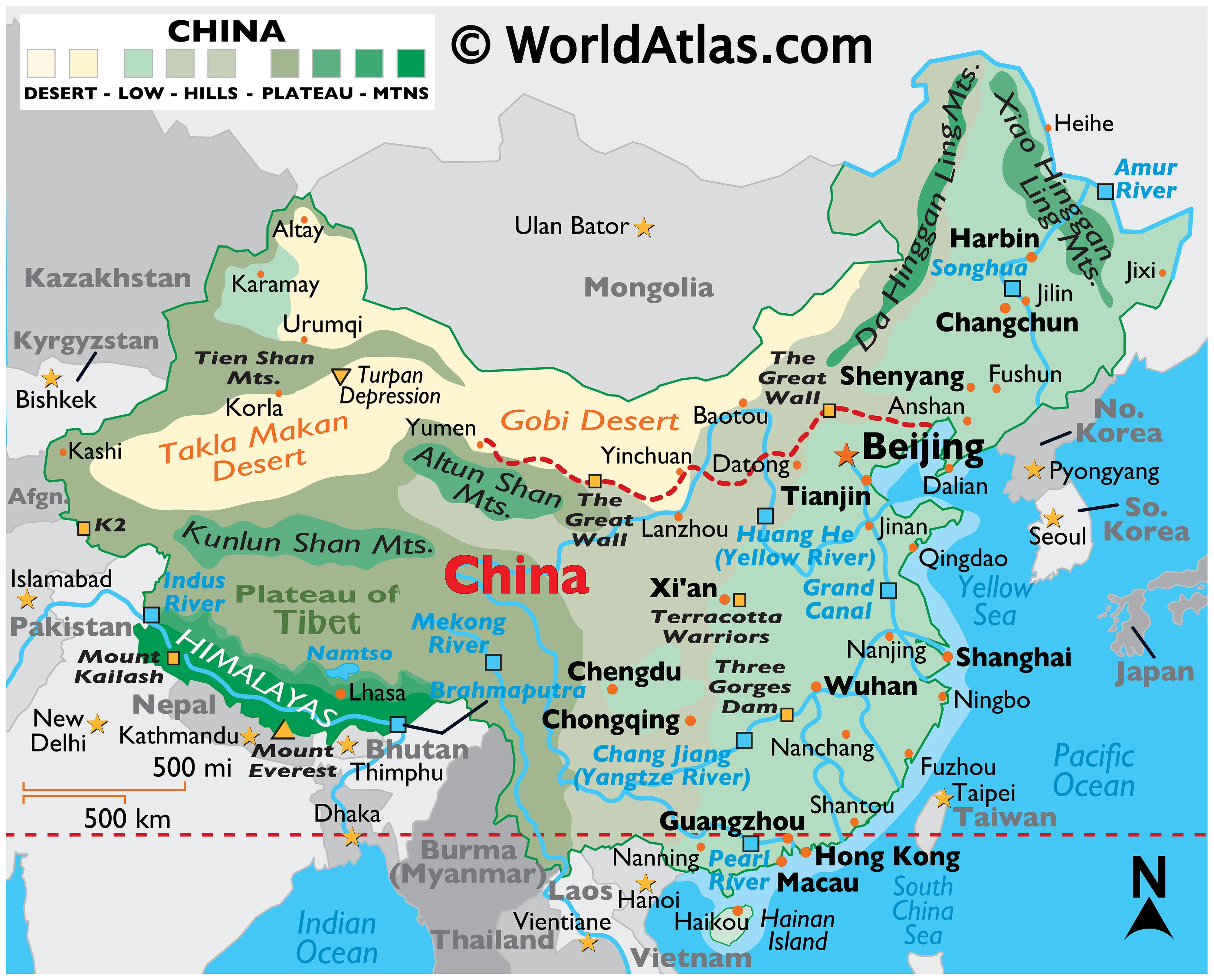
Xina
Muntanyes
Al nordest les muntanyes de Tian Shan i el desert de Taklamakan . Al nord el desert de Gobi limitant amb Mongòlia. Al sudoest la meseta del Tibet que limita amb les muntanyes del Karakoram i Pamir a l’oest amb Pakistan, i l’Himalaia al sud amb la Índia. Al centre hi ha les grans planes travessades pels grans rius.
Rius
Al nord limitant amb Rússia, el riu Amur (Heilong Jiang).
El Yellow River (Huang He) neix al Tibet i desemboca al nord, al mar groc.
Separats per les muntanyes Qin, més al sud el més llarg, el Yangtze del Tibet a prop de Shanghai. (Clima de boscos caducifolis temperats). Al sud clima subtropical, amb el Zhujiang (Pearl River), amb les contribucions del Xi (Oest), Dong (Est), and Bei (Nord), acabant amb un gran delta a Hong Kong [paisatge de turons verticals].
El riu Mekong comença a Xina al nord de l’himalaia i creuarà tot el sudest asiàtic. El Brahmaputra neix al Tibet i serà un tributari del Ganges.
(Durant la dinastia Song la Xina va quedar dividida aproximadament a l’alçada de Chengdu i Shanghai, amb els Jin al nord i els Song del sud a sota)
Mongòlia
Al sud limita amb el desert de Gobi a Xina. Al sudoest les muntanyes Altai, al nord les muntanyes Sayan. El centra i sud és estepa i desert. Al nordest més prats. És una terra molt freda, amb vents procedents de Sibèria.
[ Divisió una mica arbitrària, però ajuntar-ho amb tota Àsia o amb Europa no em sembla que ajudi]
A l’Oest limitaria amb els Urals. Al sud amb el massís de muntanyes de l’Àsia Central (Iran i Afganistan), les muntanyes Altai, limitant amb Xina i Mongòlia, Mongòlia i el riu Amur limitant amb Xina.
Hi ha una gran plana entre els Urals i el riu Yenisei, la Sibèria Occidental, travessada pel riu Ob, amb un desert al sud (actualment Kazakstan). La Sibèria Oriental és més muntanyosa i limita a l’est amb el riu Lena abans del massís Verkhoyansk. Al sud hi ha les muntanyes Sayan al nord de Mongòlia amb el llac Baikal.
La major part de Sibèria són boscos de Taiga i estepes al sud.
geografia | límits | Mediterrà, Illes , Plana Centreuropa, Rússia, Caucas
D’acord amb la classificació biogeogràfica en ecoregions, pertany al reialme Paleàrtic amb part de la regió eurosiberiana i el mediterrà (les altres són els deserts del Sahara i Aràbia, Àsia central i Àsia Oriental.
Va estar unida amb el Neàrtic (Amèrica del Nord) per un pont de terra a l’estret de Bering i en comparteixen moltes espècies.
La convenció és que limita al sud amb el mediterrà i les muntanyes del Caucas, i a l’est amb el Volga, Urals (inclou bona part de la Rússia actual).
Europe is most commonly considered to be separated from Asia by the watershed divides of the Ural and Caucasus Mountains, the Ural River, the Caspian and Black Seas and the waterways of the Turkish Straits. The European climate is largely affected by warm Atlantic currents that temper winters and summers on much of the continent, even at latitudes along which the climate in Asia and North America is severe. Further from the sea, seasonal differences are more noticeable than close to the coast.
És bàsicament una gran plana amb les muntanyes de l’orogènia alpina (66M) al sud: Pirineus, Alps i Càrpats (a més els apenins a Itàlia, relleu interior a Ibèria, massif central a França) i les highlands i muntanyes de noruega de l’orogènia caledoniana (400M).
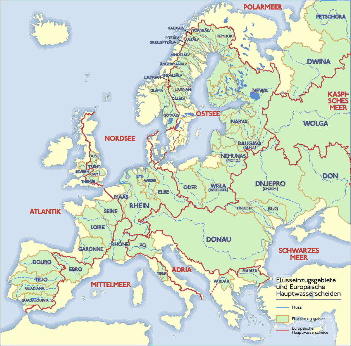
El Rin i el Danubi són els eixos principals S-N i W-E. El Volga que desemboca al Mar Caspi. El Don i Dnieper al Mar negre (NS), amb el Danubi (WE). Vistula i Oder al bàltic (i el Neva del llac Ladoga passant per Sant Petersburg). Elba, Rin, Seine i Loire a l’Atlàntic. L’Ebre, el Rhône i el Po al mediterrani.
El corrent del golf fa de “calefacció central” fent un clima més temperat que d’altres ubicacions a la mateixa latitud. A mesura que ens desplacem a l’est baixen les temperatures.
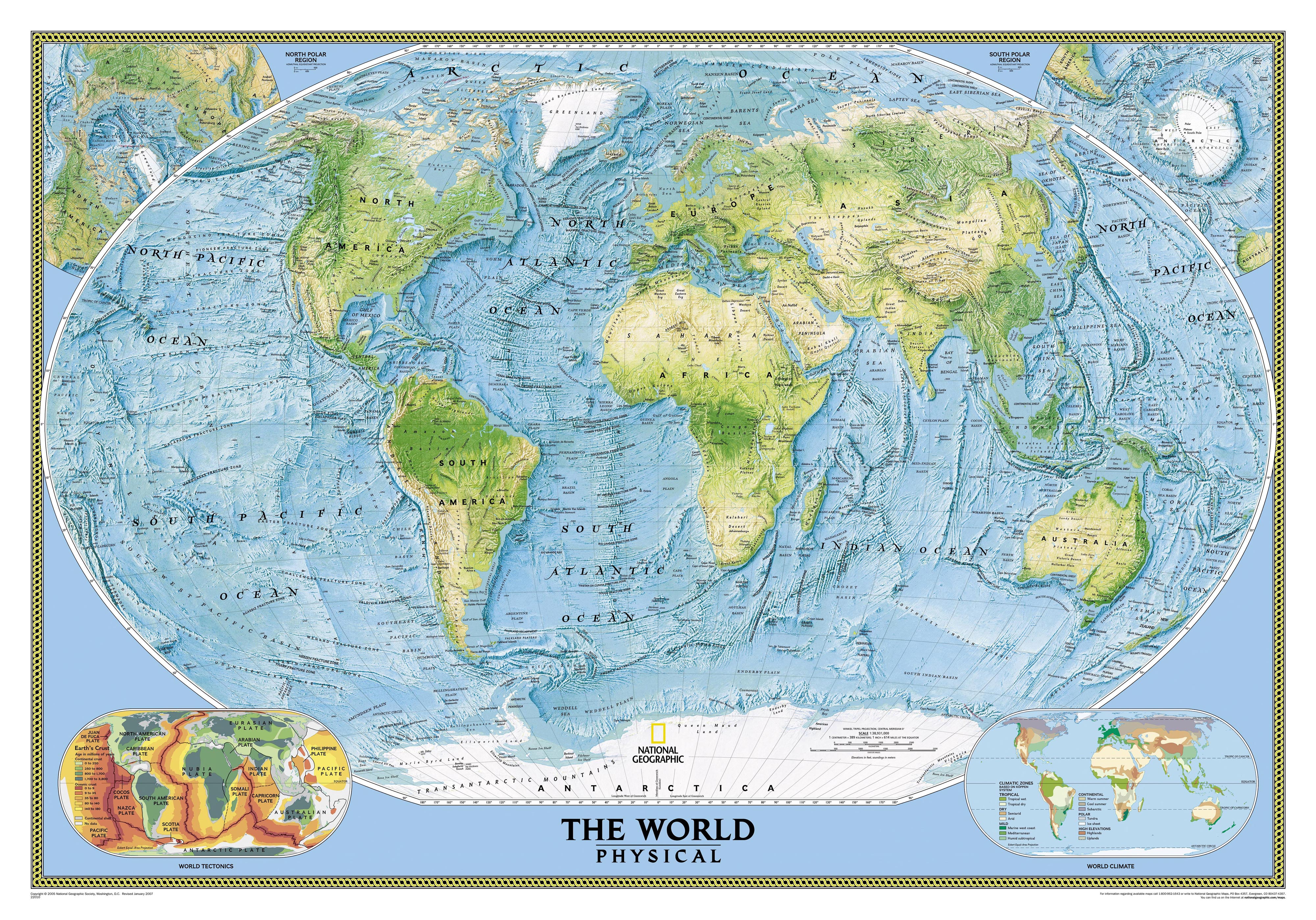
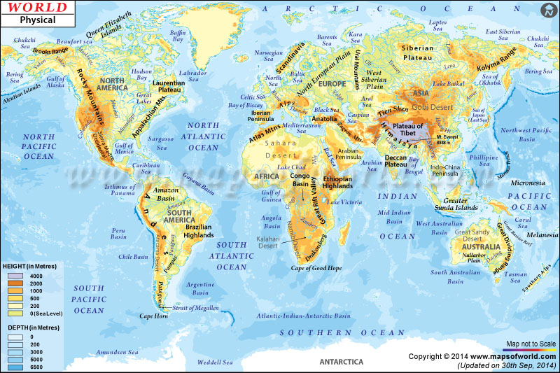
Oceà seria l’aigua salada que cobreix un 71% de la superfície de la terra. Encara que formen un continu, convencionalment el dividim en:
Pacífic, 168M km2
Atlàntic, 85M km2
Índic, 70M km2
Àrtic i Antàrtic (a vegades considerats com extensions de l’Atlàntic i Pacífic)
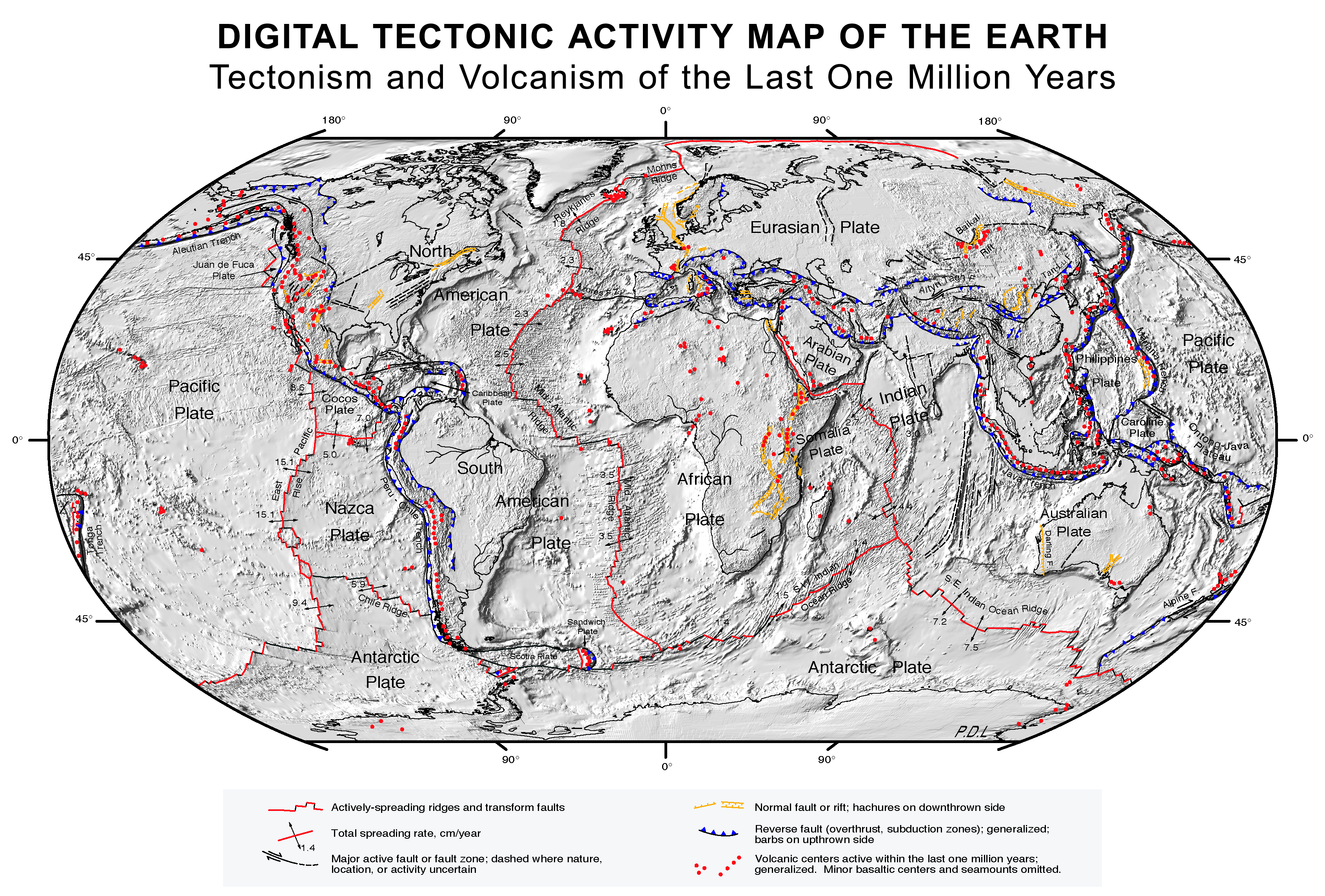
El mar té una fondària mitjana d’uns 4- 6000m enfontsant-se fins a 10 o 11000 a les foses pelàgiques. S’ha identificat una dorsal a l’atlàntic, a l’índic i al Pacífic, coincidint amb les plaques tectòniques divergents. (que en alguns punts sigui tan fons justifica aquell acudit d’un que veu el mar per primer cop i diu “quànta aigua!” i l’altre afegeix “Oh, i la que hi ha a sota que no es veu).
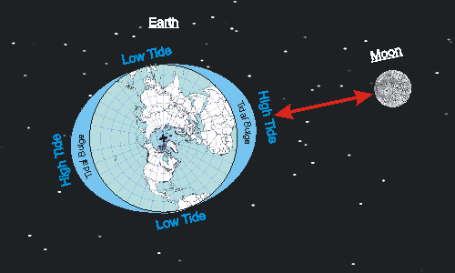
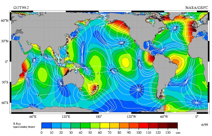
Marees
Degut a l’atracció de la lluna, la massa d’aigua canvia de nivell, donant lloc a dos màxims cada dia, amb un període de 12.42 hores, corresponent a mig dia lunar. (Hi ha dos màxims perquè no només es desplaça l’aigua propera a la lluna sinó també la terra sencera, així que el costat oposat també té marea alta).
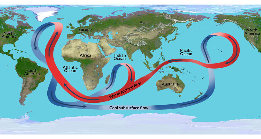
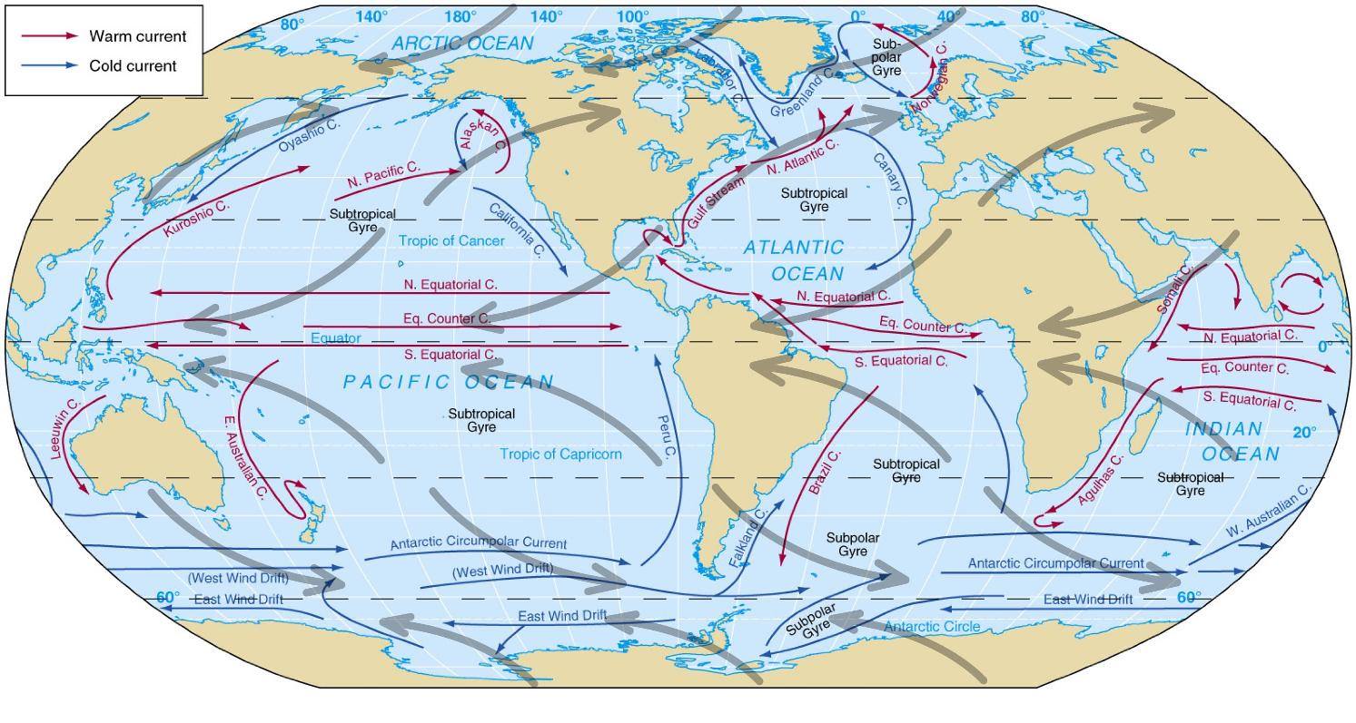
El corrent del golf puja fins a l’àrtic (calent, superfície) on s’enfonsa i baixa al sud, es desplaça a l’est i torna a pujar a l’Índic i Pacífic. Es desplaça cap a l’oest tornant a l’Atlàntic.
Corrents de superfície, les cel·les de vents intermitges empenyen l’aigua de dreta a esquerra al nord i a l’inrevés al sud.
El Niño / la Niña (BBC). Quan les temperatures a la superfícies del Pacific són més altes del normal i arriba aigua calenta a l’est (Perú). Altera el clima provocant pluges intenses. La Niña és el fenomen contrari.
Composició
La salinitat mitjana és de 31-28 g/kg, és a dir, al voltant d’un 3%, variant a les zones on es fon el glaç o desembocadures dels rius.
La salinitat és més gran als tròpics, 3.7% que no pas als pols, 2.8%
Cicle de l’aigua
A les regions polars i temperades la precipitació és més gran que l’evaporació, al tròpic a l’inrevés.
La temperatura a l’hivern és de -2º, 5º-20º, 20-25º.
Verticalment NS: les serralades al llarg del pacífic N-S: rocky mountains i Andes, per subducció de la placa oceànica del pacífic sota la continental americana (-150Ma). Les apalatxes, bàltiques i escòcia de l’orogènia caledoniana (450 a 400Ma). Urals, 300Ma.
Verticalment NS: les serralades al llarg del pacífic N-S: rocky mountains i Andes, per subducció de la placa oceànica del pacífic sota la continental americana (-150Ma). Les apalatxes, bàltiques i escòcia de l’orogènia caledoniana (450 a 400Ma). Urals, 300Ma.
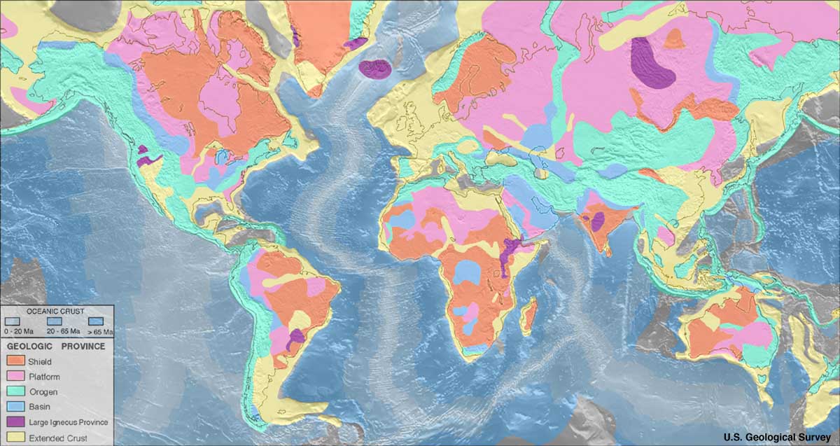
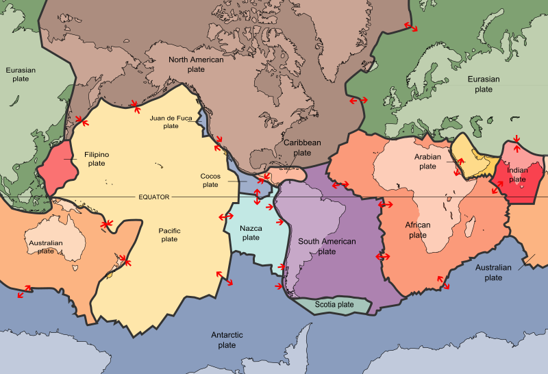
Tenim 7 grans plaques tectòniques que van desplaçant-se sobre el mantell. [les orogènies, ¿són sempre resultat d’un xoc entre plaques?]
Catalunya: a part d’alguna petita àrea emergida al carbonífer, Catalunya va estar submergida fins l’orogènia alpina fa uns 66 mA quan el xoc amb àfrica fa emergir els pirineus i la serralada costera (66-30), vulcanisme a la serralada transversal fa 10Ma . Tota la depressió era un mar obert fins que es va anar assecant a partir del Miocè.]
La superfície terrestre es refreda i es comencen a formar plaques sobre el mantell, el vapor es condensa i la pluja crea els oceans. Les parts estables s’anomenen cratons , i les altres serien les muntanyes en evolució per orogènies (províncies geològiques).
-4000 Arqueà
-2500 Proterozoic
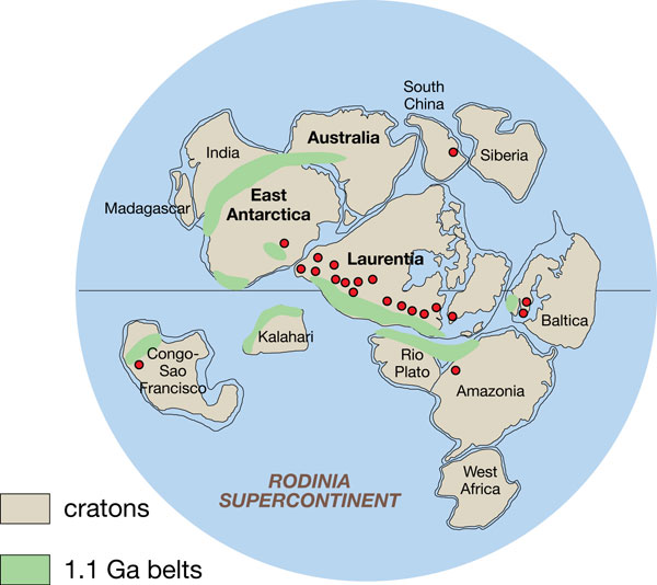
-1000 Rodinia. Les reconstruccions dels continents anteriors a 300 mA (Pangea) són incertes. Però cap el -1000 mA, la major part de les masses continentals estaven unides en un supercontinent anomenat Rodinia que es va començar a desfer als 800Ma.
Els cratons es van desplaçar cap al pol sud on van estar junts del 600 al 550 (Pannotia) fins que es van separar entre Laurasia (Laurentia, Groenlandia, Baltica, Siberia ) i Gondwana (Àfrica, Amèrica del sud, Austràlia, Antàrtica, Índia, i el SE d’Europa) . Els xocs de les masses de Laurasia constitueixen l’orogènia Grenville (1000Ma), els de Gondwana l’orogènia Pan-African (650–500 Ma). els xocs entre els cratons que formaven Gondwana.
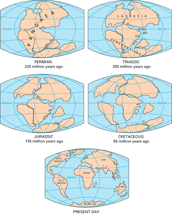
-541 Ma PALEOZOIC [unió dels continents per formar pangea amb les orogènies Caledònia i Herniciana per les col·lisions]
-490 a 390. Ordovicià i Silúric. Laurentia i Baltica xoquen amb l’orogènia Caledoniana per formar Laurussia [ICGC diu 750 480] En queden evidències a las Apalatxes, escandinavia i Escòcia.
-416 Devonià: Gondwana i Siberia s’apropen a Laurussia i en la colisió es formen els Urals Urals.
-380 a 280 Carbonífer. La col·lisió de Gondwana amb Laurussia fa l’orogènia Varisca a Europa [ICGC diu 480 a 250] (muntanyes de la península ibèrica i els Pirineus, Sud d’Irlanda i Gal·les, massís entral a França, massís del Rin, els Alps (que després seran modificats per l’orogènia alpina) o la Alleghenian a Nordamèrica (segona passada apalatxes, massís de l’Atlas a Àfrica). Es forma un únic supercontinent, Pangaea. Estava centrat a l’equador i envoltat d’un superoceà, Panthalassa.
-280 Permià -252
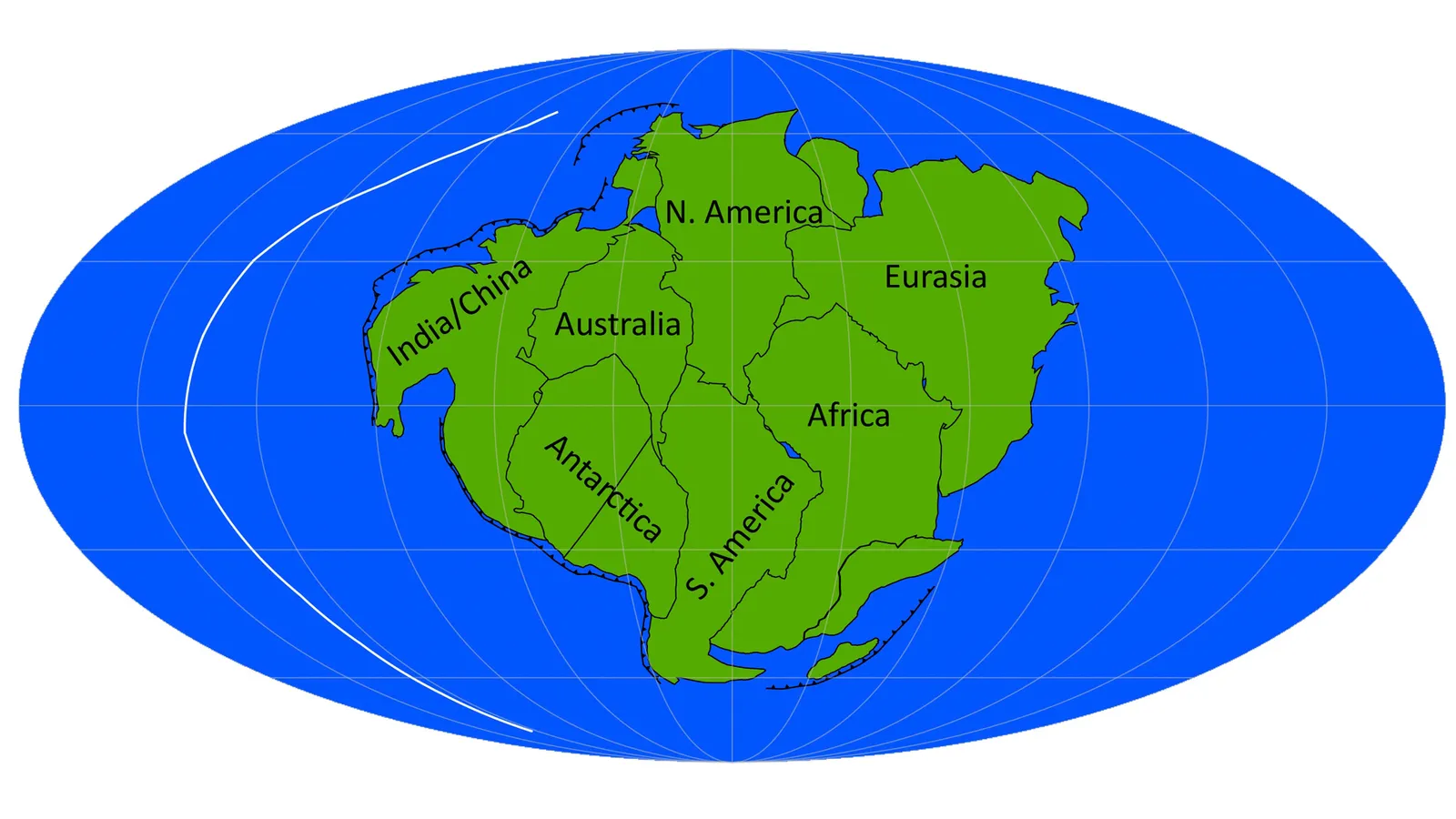
-256 MESOZOIC [Divisió de Pangea, Andes i Rocoses per subducció del pacífic)
-175 Ma Pangea es divideix entre Laurasia and Gondwana
-80 a -55 Ma Serralada nordamericana: Sierra Madre, Rocky mountains. Laramide orogeny
-66 CENOZOIC [ Àfrica i la índia pugen ja i xoca amb Lauràsia, orogènia alpina]
Els continents s’acaben de desplaçar fins a les posicions actuals. Australia, puja al nord i topa amb el Sudest asiàtic; Antarctica es desplaça al pol sud. L’oceà Atlantic s’eixampla només fa 2.8. Sudamèrica s’uniex al nord amb l’istme de Panamà.
A partir de la hipòtesi de Wegener s’ha establert que la litosfera, amb l’escorça i el mantell residual, amb un gruix d’uns 100 km, està formada per 7 grans plaques que es desplacen, deriva continental, sobre el mantell. Quan convergeix un placa oceànica amb una continental ficant-se a sota, es forma una serralada litoral [Amèrica i el pacífic]. Quan topen dues plaques continentals es forma una cadena de muntanyes [Pirineus, Himalaia]. Quan divergeixen, es formen oceans, o rifts.
Les plaques es desplacen 3-7 cm cada any.
A les zones de contacte és on hi ha més activitat volcànica.
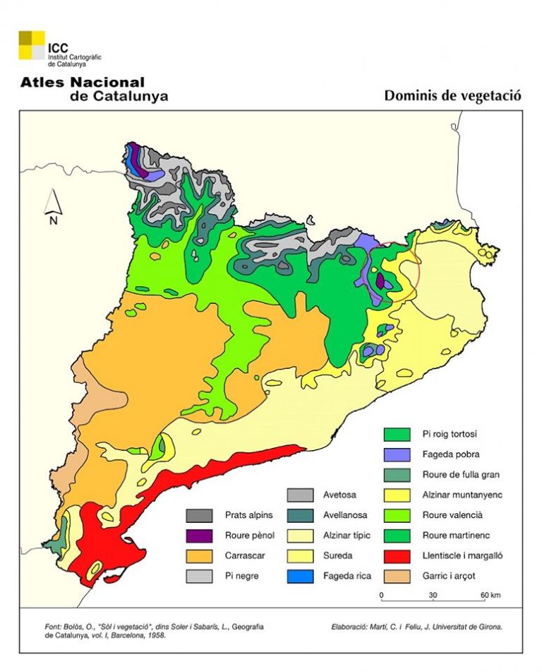
Catalunya: Mapa de cobertes del sol a Catalunya, Observatori de paisatges, Folch
Films
El món
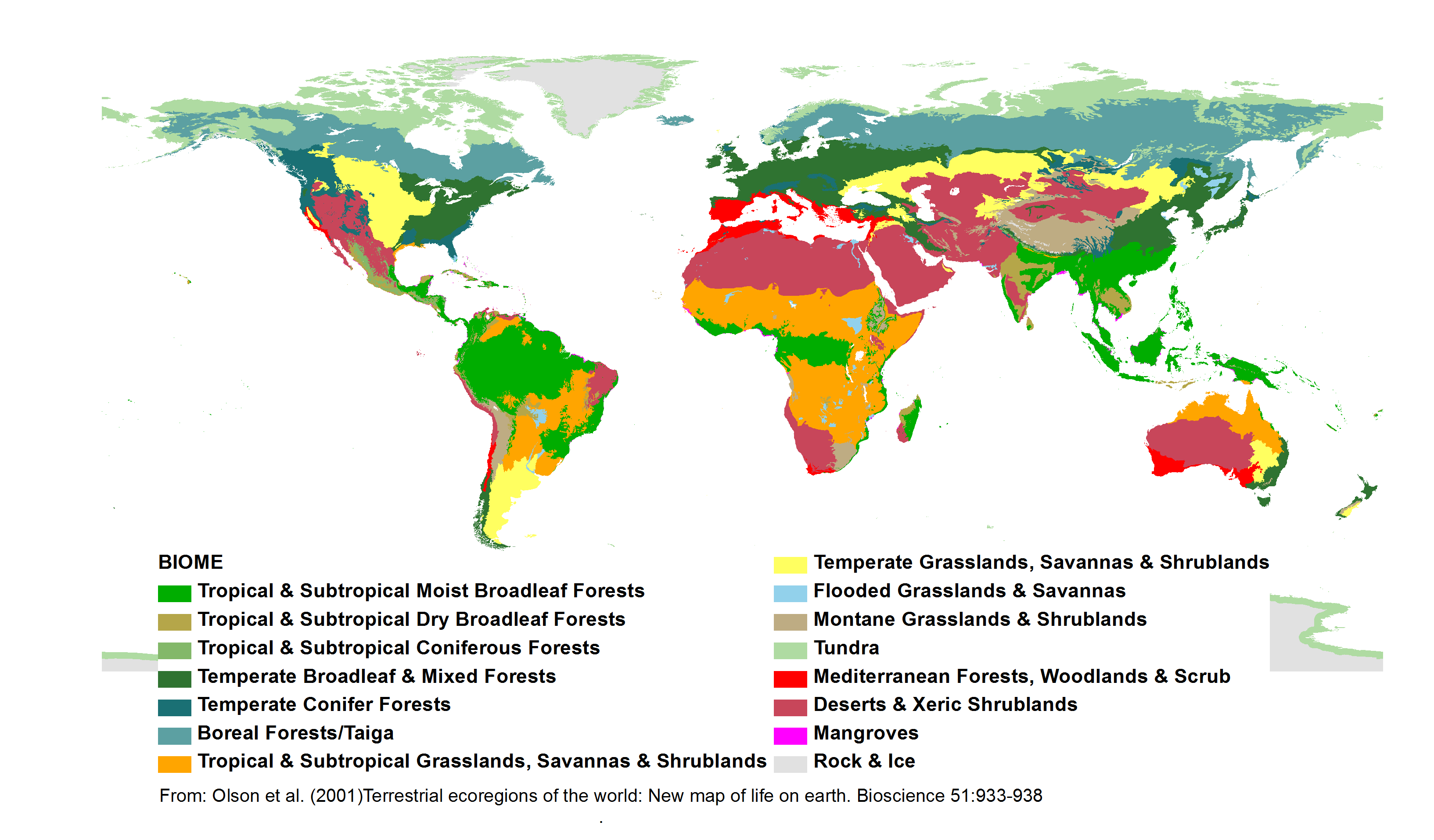
Els estudis de zones climàtiques proposen 15 biomes de 4 zones, fred, temperat, desert, tròpic. Les guies de naturalesa de les latituds temperades, que normalment no tenen ni desert ni tròpics, inclouen muntanya, rius i llacs, mars i costes. [Dins de cada bioma, l’hàbitat concret varia segons si la zona es troba a la plana, la muntanya, o al costat d’un riu]. La base de dades d’ecoregions ens dóna una idea de quin Bioma hi ha a cada lloc del món. aquesta classificació no dóna raó de quin % de la terra està ocupat per l’agricultura.
Fred: 3 els pols roca i gel, la Tundra, la Taiga (90º a 60º)
Temperat: 4 Els boscos de coníferes, caducifolis, mediterranis, els prats i estepes (60º a 30º)
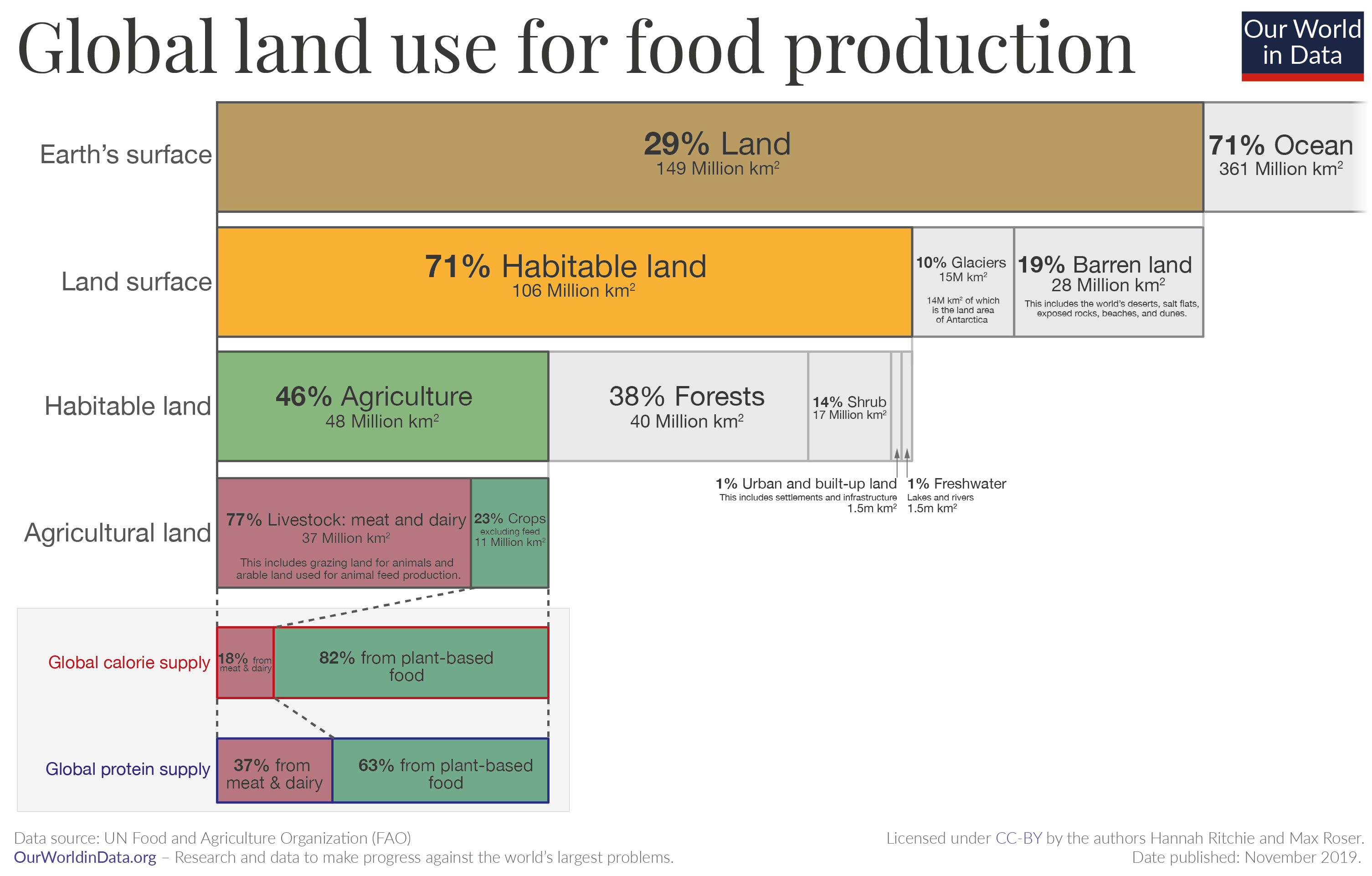
La superfície del planeta és 29% terra, del qual un 71% seria habitable, la resta deserts, roques i platja. D’aquest 71% gairebé la meitat, un 46% està dedicat a l’agricultura, i la resta són 38% boscos, 14% arbusts, 1% aigua dolça i 1% edificis i xarxa viària. La terra agrícola es dedica en un 77% a pastures, que aporten un 18% de les calories i un 37% de les proteïnes, mentre que un 23% són conreus que aporten un 82% de les calories i un 63% de les proteïnes. (Our World in data)
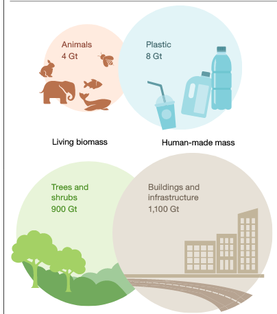
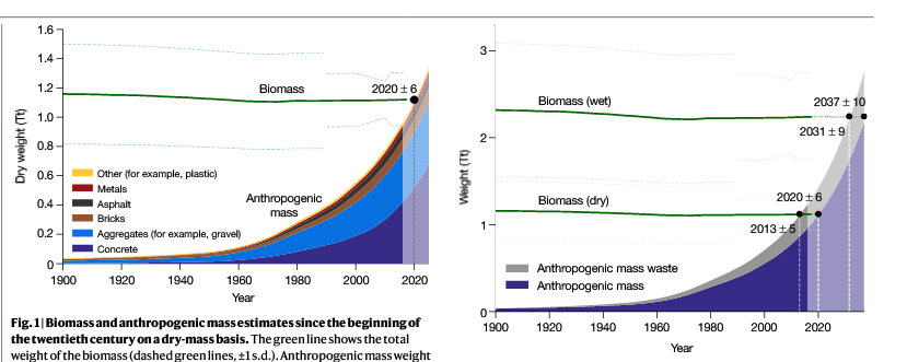
Es calcula que el 2020 la massa d’origen humà, edificis, carreteres, objectes és més gran que la massa biològica d’animals i plantes. (article)
Europa
Hàbitats Corine: Dona una llista de totes les zones naturales d’europa. És incomplet ja que només recull les zones protegides i les dades també són incompletes, no sempre hi ha tota la vegetació i plantes. Consulta llista de països > hàbitats > pàgina amb mapa ecoregions i llista d’espècies
1 – Ambients litorals i salins
2 – Aigües continentals
3 – Vegetació arbustiva i herbàcia (Prats i pastures)
4 – Boscos
5 – Molleres i aiguamolls
6 – Roques, tarteres, glaceres, coves
7 – [no existeix]
8 – Terres agrícoles i àrees antròpiques
9 – Àrees talades o cremades
S’identifiquen fins a 600 hàbitats. Per a cadascun, la documentació en PDF identifica la fauna més comuna. De la web del Corinne es pot descarregar una base de dades on es llisten els biòtops d’Europa i les espècies animals i vegetals.
La guia Plantas y animales de Europa de Harry Garms, que és la que faig servir més per identificar animals i plantes divideix Europa en tres zones, Àrtic (isoterma 10º al juliol), temperada i mediterrània(Península Ibèrica, costa francesa, Itàlia, Balcans).
Boscos i selves: coníferes al nord i muntanya, caducifolis i mixtes al mediterrani
Tundra, landa (heath), torbera (bog): molses, arbustos. Amb límits de fins on arriben els rèptils i els amfibis.
Aigües continentals: llacs, rius, estanys
Mar i costes
Praderies, sabanes i matollars temperats (Temperate grasslands, savannas, and shrublands)
Alta muntanya alpina i subalpina: prats, pi negre i avetosa
Muntanya mitjana medioeuropea: fagedes i rouredes humides, pi roig i avellanosa
Muntanya mediterrànea culminal: brolles d’eriçó, savinoses [ La Jonquera, Gavarres]
Muntanya i terra baixa mediterrània: roureda seca i roure martinenc, pi roig i roure de fulla petita, alzinar muntanyenc, alzinar litoral i sureda, carrascar i alzinar continental, alzinar baleàric, màquia continental de garric i arçot, màquina litoral de garric i olivella
Euro-Siberian region. (Europa, Rússia) The boreal and temperate Euro-Siberian region is the Palearctic’s largest biogeographic region, which transitions from tundra in the northern reaches of Russia and Scandinavia to the vast taiga, the boreal coniferous forests which run across the continent. South of the taiga are a belt of temperate broadleaf and mixed forests and temperate coniferous forests. This vast Euro-Siberian region is characterized by many shared plant and animal species, and has many affinities with the temperate and boreal regions of the Nearctic ecoregion of North America. Eurasia and North America were often connected by the Bering land bridge, and have very similar mammal and bird fauna, with many Eurasian species having moved into North America, and fewer North American species having moved into Eurasia. Many zoologists consider the Palearctic and Nearctic to be a single Holarctic realm. The Palearctic and Nearctic also share many plant species, which botanists call the Arcto-Tertiary Geoflora.
Mediterranean Basin. The lands bordering the Mediterranean Sea in southern Europe, north Africa, and western Asia are home to the Mediterranean Basin ecoregions, which together constitute the world’s largest and most diverse mediterranean climate region of the world, with generally mild, rainy winters and hot, dry summers. The Mediterranean basin’s mosaic of Mediterranean forests, woodlands, and scrub are home to 13,000 endemic species. The Mediterranean basin is also one of the world’s most endangered biogeographic regions; only 4% of the region’s original vegetation remains, and human activities, including overgrazing, deforestation, and conversion of lands for pasture, agriculture, or urbanization, have degraded much of the region. Formerly the region was mostly covered with forests and woodlands, but heavy human use has reduced much of the region to the sclerophyll shrublands known as chaparral, matorral, maquis, or garrigue. Conservation International has designated the Mediterranean basin as one of the world’s biodiversity hotspots.
Sahara and Arabian deserts. A great belt of deserts, including the Atlantic coastal desert, Sahara desert, and Arabian desert, separates the Palearctic and Afrotropic ecoregions. This scheme includes these desert ecoregions in the palearctic realm; other biogeographers identify the realm boundary as the transition zone between the desert ecoregions and the Mediterranean basin ecoregions to the north, which places the deserts in the Afrotropic, while others place the boundary through the middle of the desert.
Western and Central Asia. The Caucasus mountains, which run between the Black Sea and the Caspian Sea, are a particularly rich mix of coniferous, broadleaf, and mixed forests, and include the temperate rain forests of the Euxine-Colchic deciduous forests ecoregion. Central Asia and the Iranian plateau are home to dry steppe grasslands and desert basins, with montane forests, woodlands, and grasslands in the region’s high mountains and plateaux. In southern Asia the boundary of the Palearctic is largely altitudinal. The middle altitude foothills of the Himalaya between about 2000–2500 m form the boundary between the Palearctic and Indomalaya ecoregions.
East Asia. China, Korea and Japan are more humid and temperate than adjacent Siberia and Central Asia, and are home to rich temperate coniferous, broadleaf, and mixed forests, which are now mostly limited to mountainous areas, as the densely populated lowlands and river basins have been converted to intensive agricultural and urban use. East Asia was not much affected by glaciation in the ice ages, and retained 96 percent of Pliocene[citation needed] tree genera, while Europe retained only 27 percent. In the subtropical region of southern China and southern edge of the Himalayas, the Palearctic temperate forests transition to the subtropical and tropical forests of Indomalaya, creating a rich and diverse mix of plant and animal species. The mountains of southwest China are also designated as a biodiversity hotspot. In Southeastern Asia, high mountain ranges form tongues of Palearctic flora and fauna in northern Indochina and southern China. Isolated small outposts (sky islands) occur as far south as central Myanmar (on Nat Ma Taung, 3050 m), northernmost Vietnam (on Fan Si Pan, 3140 m) and the high mountains of Taiwan.
The Canadian Shield bioregion extends across the northern portion of the continent, from the Aleutian Islands to Newfoundland. It includes the Nearctic’s Arctic Tundra and Boreal forest ecoregions.;;In terms of floristic provinces, it is represented by part of the Canadian Province of the Circumboreal Region.
The Eastern North America bioregion includes the temperate broadleaf and mixed forests of the Eastern United States and southeastern Canada, the Great Plains temperate grasslands of the Central United States and south-central Canada, the temperate coniferous forests of the Southeastern United States, including Central Florida. In terms of floristic provinces, it is represented by the North American Atlantic Region and part of the Canadian Province of the Circumboreal Region.
The Western North America bioregion includes the temperate coniferous forests of the coastal and mountain regions of southern Alaska, western Canada, and the Western United States from the Pacific Coast and Northern California to the Rocky Mountains, as well as the cold-winter intermountain deserts and xeric shrublands and temperate grasslands and shrublands of the Western United States.;;In terms of floristic provinces, it is represented by the Rocky Mountain region.
Northern Mexico and Southwestern North America. The Northern Mexico bioregion includes the mild-winter to cold-winter deserts and xeric shrublands of northern Mexico, Southern California, and the Southwestern United States, including the Chihuahuan, Sonoran, and Mojave Deserts. The Mediterranean climate ecoregions of the Southern and Central Coast of California include the California chaparral and woodlands, California coastal sage and chaparral, California interior chaparral and woodlands, and California montane chaparral and woodlands.;;The bioregion also includes the warm temperate and subtropical pine and pine-oak forests, including the Arizona Mountains forests and the Sierra Madre Occidental, Sierra Madre Oriental, and Sierra Juarez and San Pedro Martir pine-oak forests.
Sahel and Sudan. South of the Sahara, two belts of tropical grassland and savanna run east and west across the continent, from the Atlantic Ocean to the Ethiopian Highlands. Immediately south of the Sahara lies the Sahel belt, a transitional zone of semi-arid short grassland and acacia savanna. Rainfall increases further south in the Sudanian Savanna, also known simply as the Sudan, a belt of taller grasslands and savannas. The Sudanian Savanna is home to two great flooded grasslands, the Sudd wetland in South Sudan, and the Niger Inland Delta in Mali. The forest-savanna mosaic is a transitional zone between the grasslands and the belt of tropical moist broadleaf forests near the equator.
Southern Arabian woodlands. South Arabia, expressed as being mostly Yemen and parts of western Oman and southwestern Saudi Arabia, has few permanent forests. Some of the notable are Jabal Bura’, Jabal Raymah, and Jabal Badaj in the Yemeni highland escarpment, and the seasonal forests in eastern Yemen and the Dhofar region of Oman. Other woodlands scatter the land and are very small and are predominantly juniper or acacia forest
Forest zone The forest zone, a belt of lowland tropical moist broadleaf forests, runs across most of equatorial Africa’s intertropical convergence zone. The Upper Guinean forests of West Africa extend along the coast from Guinea to Togo. The Dahomey Gap, a zone of forest-savanna mosaic that reaches to the coast, separates the Upper Guinean forests from the Lower Guinean forests, which extend along the Gulf of Guinea from eastern Benin through Cameroon and Gabon to the western Democratic Republic of the Congo. The largest tropical forest zone in Africa is the Congolian forests of the Congo Basin in Central Africa. A belt of tropical moist broadleaf forest also runs along the Indian Ocean coast, from southern Somalia to South Africa.
East African grasslands and savannas Acacia-Commiphora grasslands; Serengeti
Eastern Africa’s highlands Afromontane region, from the Ethiopian Highlands to the Drakensberg Mountains of South Africa, including the East African Rift. Distinctive flora, including Podocarpus and Afrocarpus, as well as giant Lobelias and Senecios. Ethiopian Highlands; Albertine rift montane forests; East African montane forests and Eastern Arc forests
Southern African woodlands, savannas, and grasslands Miombo woodlands; Zambezian mopane and Baikiaea woodlands; Bushveld
Deserts of southern Africa Namib Desert; Kalahari Desert; Karoo; Tankwa Karoo; Richtersveld
Cape floristic region The Cape floristic region, at Africa’s southern tip, is a Mediterranean climate region that is home to a significant number of endemic taxa, as well as to plant families like the proteas (Proteaceae) that are also found in the Australasian realm
Madagascar and the Indian Ocean islands Madagascar and neighboring islands form a distinctive sub-region of the realm, with numerous endemic taxa like the lemurs. Madagascar and the Seychelles are old pieces of the ancient supercontinent of Gondwana, and broke away from Africa millions of years ago. Other Indian Ocean islands, like the Comoros and Mascarene Islands, are volcanic islands that formed more recently. Madagascar contains several important biospheres, as its biodiversity and ratio of endemicism is extremely high.
Indian Subcontinent. The Indian Subcontinent bioregion covers most of India, Pakistan, Bangladesh, Nepal, Bhutan, and Sri Lanka. The Hindu Kush, Karakoram, Himalaya, and Patkai ranges bound the bioregion on the northwest, north, and northeast; these ranges were formed by the collision of the northward-drifting Indian subcontinent with Asia beginning 45 million years ago. The Hindu Kush, Karakoram, and Himalaya are a major biogeographic boundary between the subtropical and tropical flora and fauna of the Indian subcontinent and the temperate-climate Palearctic realm.
Indochina The Indochina bioregion includes most of mainland Southeast Asia, including Myanmar, Thailand, Laos, Vietnam, and Cambodia, as well as the subtropical forests of southern China.
Sunda shelf and the Philippines Malesia is a botanical province which straddles the boundary between Indomalaya and Australasia. It includes the Malay Peninsula and the western Indonesian islands (known as Sundaland), the Philippines, the eastern Indonesian islands, and New Guinea. While the Malesia has much in common botanically, the portions east and west of the Wallace Line differ greatly in land animal species; Sundaland shares its fauna with mainland Asia, while terrestrial fauna on the islands east of the Wallace line are derived at least in part from species of Australian origin, such as marsupial mammals and ratite birds.
Amazonia The Amazonia bioregion is mostly covered by tropical moist broadleaf forest, including the vast Amazon rainforest, which stretches from the Andes mountains to the Atlantic Ocean, and the lowland forests of the Guianas. The bioregion also includes tropical savanna and tropical dry forest ecoregions.
Caribbean
Central America
Central Andes
Eastern South America Eastern South America includes the Caatinga xeric shrublands of northeastern Brazil, the broad Cerrado grasslands and savannas of the Brazilian Plateau, and the Pantanal and Chaco grasslands. The diverse Atlantic forests of eastern Brazil are separated from the forests of Amazonia by the Caatinga and Cerrado, and are home to a distinct flora and fauna.
Northern Andes
Orinoco The Orinoco is a region of humid forested broadleaf forest and wetland primarily comprising the drainage basin for the Orinoco River and other adjacent lowland forested areas. This region includes most of Venezuela and parts of Colombia.
Southern South America The temperate forest ecoregions of southwestern South America, including the temperate rain forests of the Valdivian temperate rain forests and Magellanic subpolar forests ecoregions, and the Juan Fernández Islands and Desventuradas Islands, are a refuge for the ancient Antarctic flora, which includes trees like the southern beech (Nothofagus), podocarps, the alerce (Fitzroya cupressoides), and Araucaria pines like the monkey-puzzle tree (Araucaria araucana). These magnificent rainforests are endangered by extensive logging and their replacement by fast-growing non-native pines and eucalyptus.
Micronesia which lies north of the equator and west of the International Date Line, includes the Mariana Islands in the northwest, the Caroline Islands in the center, the Marshall Islands to the west and the islands of Kiribati in the southeast.
Melanesia to the southwest, includes New Guinea, the world’s second largest island after Greenland and by far the largest of the Pacific islands. The other main Melanesian groups from north to south are the Bismarck Archipelago, the Solomon Islands, Santa Cruz, Vanuatu, Fiji and New Caledonia.[71]
Polynesia stretching from Hawaii in the north to New Zealand in the south, also encompasses Tuvalu, Tokelau, Samoa, Tonga and the Kermadec Islands to the west, the Cook Islands, Society Islands and Austral Islands in the center, and the Marquesas Islands, Tuamotu, Mangareva Islands, and Easter Island to the east.
Australasia
Australasia comprises Australia, New Zealand, the island of New Guinea, and neighbouring islands in the Pacific Ocean. Most of Australasia lies on the southern portion of the Indo-Australian Plate, flanked by the Indian Ocean to the west and the Southern Ocean to the south.[73] The bulk of Australasia sits on the Indo-Australian Plate, together with India.