
Hi ha 8 grans reialmes o ecozones, que es divideixen en unes 867 ecoregions segons el WWF. (Resolve). Aquestes es poden classificar en 15 biomes terrestres. [Geografia] | query ecoregions [ pendent de fer sortir mapa sencer] | ntroduides per Alfred Russell Wallace i Miklos Udvardy (Ciències de la vida sXIX)
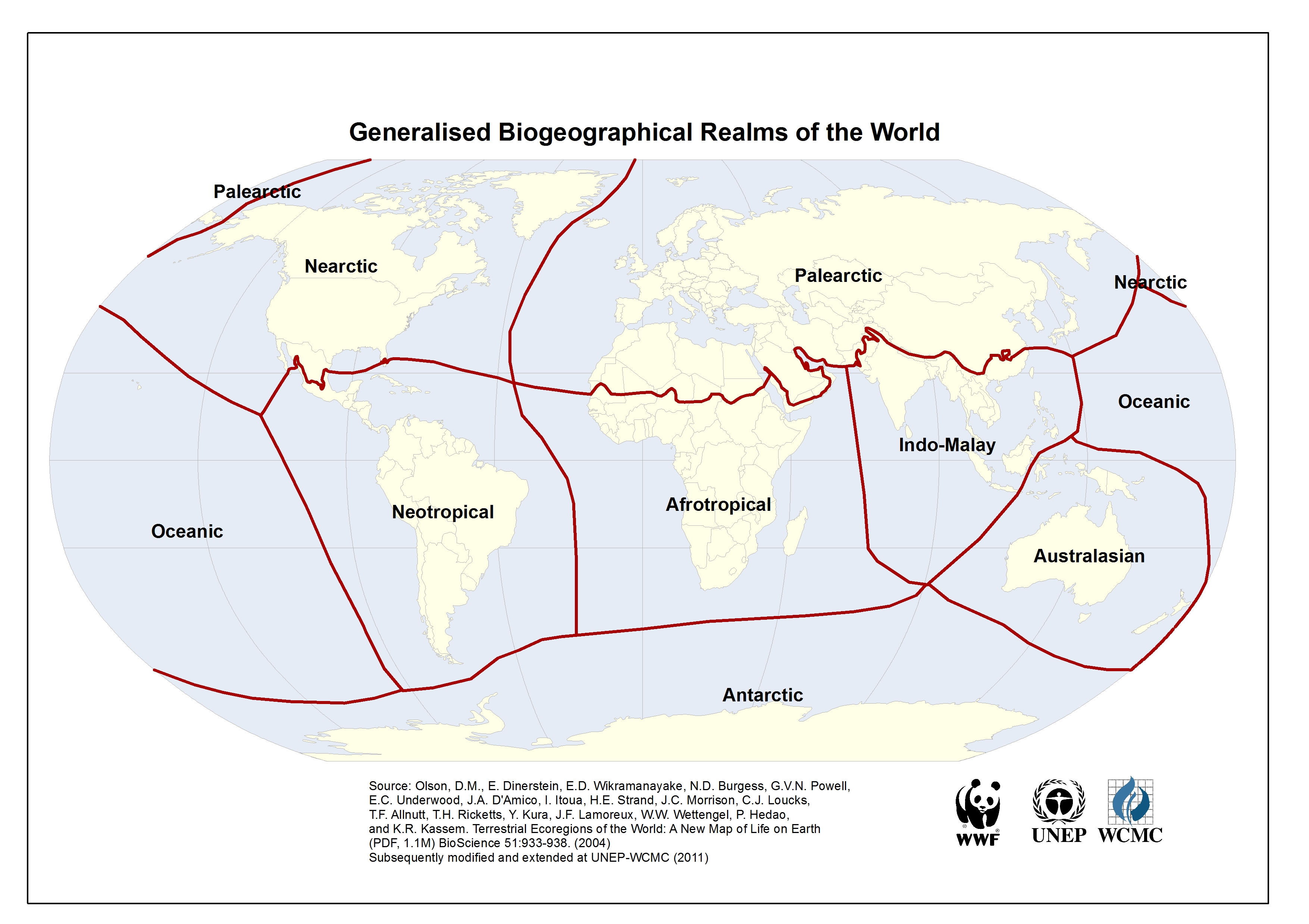
Identifiquem 33 grans bioregions als 8 Reialmes: Paleartic, Neartic, Afrotropic, Indomalai, Neotropic, Australasia i Ocenia, Antàrtic
[La clau als Ecocodis és PA NA AT IM NT AA OC]
- Euro-Siberian region. (Europa, Rússia) The boreal and temperate Euro-Siberian region is the Palearctic’s largest biogeographic region, which transitions from tundra in the northern reaches of Russia and Scandinavia to the vast taiga, the boreal coniferous forests which run across the continent. South of the taiga are a belt of temperate broadleaf and mixed forests and temperate coniferous forests. This vast Euro-Siberian region is characterized by many shared plant and animal species, and has many affinities with the temperate and boreal regions of the Nearctic ecoregion of North America. Eurasia and North America were often connected by the Bering land bridge, and have very similar mammal and bird fauna, with many Eurasian species having moved into North America, and fewer North American species having moved into Eurasia. Many zoologists consider the Palearctic and Nearctic to be a single Holarctic realm. The Palearctic and Nearctic also share many plant species, which botanists call the Arcto-Tertiary Geoflora.
- Mediterranean Basin. The lands bordering the Mediterranean Sea in southern Europe, north Africa, and western Asia are home to the Mediterranean Basin ecoregions, which together constitute the world’s largest and most diverse mediterranean climate region of the world, with generally mild, rainy winters and hot, dry summers. The Mediterranean basin’s mosaic of Mediterranean forests, woodlands, and scrub are home to 13,000 endemic species. The Mediterranean basin is also one of the world’s most endangered biogeographic regions; only 4% of the region’s original vegetation remains, and human activities, including overgrazing, deforestation, and conversion of lands for pasture, agriculture, or urbanization, have degraded much of the region. Formerly the region was mostly covered with forests and woodlands, but heavy human use has reduced much of the region to the sclerophyll shrublands known as chaparral, matorral, maquis, or garrigue. Conservation International has designated the Mediterranean basin as one of the world’s biodiversity hotspots.
- Sahara and Arabian deserts. A great belt of deserts, including the Atlantic coastal desert, Sahara desert, and Arabian desert, separates the Palearctic and Afrotropic ecoregions. This scheme includes these desert ecoregions in the palearctic realm; other biogeographers identify the realm boundary as the transition zone between the desert ecoregions and the Mediterranean basin ecoregions to the north, which places the deserts in the Afrotropic, while others place the boundary through the middle of the desert.
- Western and Central Asia. The Caucasus mountains, which run between the Black Sea and the Caspian Sea, are a particularly rich mix of coniferous, broadleaf, and mixed forests, and include the temperate rain forests of the Euxine-Colchic deciduous forests ecoregion. Central Asia and the Iranian plateau are home to dry steppe grasslands and desert basins, with montane forests, woodlands, and grasslands in the region’s high mountains and plateaux. In southern Asia the boundary of the Palearctic is largely altitudinal. The middle altitude foothills of the Himalaya between about 2000–2500 m form the boundary between the Palearctic and Indomalaya ecoregions.
- East Asia. China, Korea and Japan are more humid and temperate than adjacent Siberia and Central Asia, and are home to rich temperate coniferous, broadleaf, and mixed forests, which are now mostly limited to mountainous areas, as the densely populated lowlands and river basins have been converted to intensive agricultural and urban use. East Asia was not much affected by glaciation in the ice ages, and retained 96 percent of Pliocene[citation needed] tree genera, while Europe retained only 27 percent. In the subtropical region of southern China and southern edge of the Himalayas, the Palearctic temperate forests transition to the subtropical and tropical forests of Indomalaya, creating a rich and diverse mix of plant and animal species. The mountains of southwest China are also designated as a biodiversity hotspot. In Southeastern Asia, high mountain ranges form tongues of Palearctic flora and fauna in northern Indochina and southern China. Isolated small outposts (sky islands) occur as far south as central Myanmar (on Nat Ma Taung, 3050 m), northernmost Vietnam (on Fan Si Pan, 3140 m) and the high mountains of Taiwan.
- The Canadian Shield bioregion extends across the northern portion of the continent, from the Aleutian Islands to Newfoundland. It includes the Nearctic’s Arctic Tundra and Boreal forest ecoregions.;;In terms of floristic provinces, it is represented by part of the Canadian Province of the Circumboreal Region.
- The Eastern North America bioregion includes the temperate broadleaf and mixed forests of the Eastern United States and southeastern Canada, the Great Plains temperate grasslands of the Central United States and south-central Canada, the temperate coniferous forests of the Southeastern United States, including Central Florida. In terms of floristic provinces, it is represented by the North American Atlantic Region and part of the Canadian Province of the Circumboreal Region.
- The Western North America bioregion includes the temperate coniferous forests of the coastal and mountain regions of southern Alaska, western Canada, and the Western United States from the Pacific Coast and Northern California to the Rocky Mountains, as well as the cold-winter intermountain deserts and xeric shrublands and temperate grasslands and shrublands of the Western United States.;;In terms of floristic provinces, it is represented by the Rocky Mountain region.
- Northern Mexico and Southwestern North America. The Northern Mexico bioregion includes the mild-winter to cold-winter deserts and xeric shrublands of northern Mexico, Southern California, and the Southwestern United States, including the Chihuahuan, Sonoran, and Mojave Deserts. The Mediterranean climate ecoregions of the Southern and Central Coast of California include the California chaparral and woodlands, California coastal sage and chaparral, California interior chaparral and woodlands, and California montane chaparral and woodlands.;;The bioregion also includes the warm temperate and subtropical pine and pine-oak forests, including the Arizona Mountains forests and the Sierra Madre Occidental, Sierra Madre Oriental, and Sierra Juarez and San Pedro Martir pine-oak forests.
- Sahel and Sudan. South of the Sahara, two belts of tropical grassland and savanna run east and west across the continent, from the Atlantic Ocean to the Ethiopian Highlands. Immediately south of the Sahara lies the Sahel belt, a transitional zone of semi-arid short grassland and acacia savanna. Rainfall increases further south in the Sudanian Savanna, also known simply as the Sudan, a belt of taller grasslands and savannas. The Sudanian Savanna is home to two great flooded grasslands, the Sudd wetland in South Sudan, and the Niger Inland Delta in Mali. The forest-savanna mosaic is a transitional zone between the grasslands and the belt of tropical moist broadleaf forests near the equator.
- Southern Arabian woodlands. South Arabia, expressed as being mostly Yemen and parts of western Oman and southwestern Saudi Arabia, has few permanent forests. Some of the notable are Jabal Bura’, Jabal Raymah, and Jabal Badaj in the Yemeni highland escarpment, and the seasonal forests in eastern Yemen and the Dhofar region of Oman. Other woodlands scatter the land and are very small and are predominantly juniper or acacia forest
- Forest zone The forest zone, a belt of lowland tropical moist broadleaf forests, runs across most of equatorial Africa’s intertropical convergence zone. The Upper Guinean forests of West Africa extend along the coast from Guinea to Togo. The Dahomey Gap, a zone of forest-savanna mosaic that reaches to the coast, separates the Upper Guinean forests from the Lower Guinean forests, which extend along the Gulf of Guinea from eastern Benin through Cameroon and Gabon to the western Democratic Republic of the Congo. The largest tropical forest zone in Africa is the Congolian forests of the Congo Basin in Central Africa. A belt of tropical moist broadleaf forest also runs along the Indian Ocean coast, from southern Somalia to South Africa.
- East African grasslands and savannas Acacia-Commiphora grasslands; Serengeti
- Eastern Africa’s highlands Afromontane region, from the Ethiopian Highlands to the Drakensberg Mountains of South Africa, including the East African Rift. Distinctive flora, including Podocarpus and Afrocarpus, as well as giant Lobelias and Senecios. Ethiopian Highlands; Albertine rift montane forests; East African montane forests and Eastern Arc forests
- Southern African woodlands, savannas, and grasslands Miombo woodlands; Zambezian mopane and Baikiaea woodlands; Bushveld
Deserts of southern Africa Namib Desert; Kalahari Desert; Karoo; Tankwa Karoo; Richtersveld - Cape floristic region The Cape floristic region, at Africa’s southern tip, is a Mediterranean climate region that is home to a significant number of endemic taxa, as well as to plant families like the proteas (Proteaceae) that are also found in the Australasian realm
- Madagascar and the Indian Ocean islands Madagascar and neighboring islands form a distinctive sub-region of the realm, with numerous endemic taxa like the lemurs. Madagascar and the Seychelles are old pieces of the ancient supercontinent of Gondwana, and broke away from Africa millions of years ago. Other Indian Ocean islands, like the Comoros and Mascarene Islands, are volcanic islands that formed more recently. Madagascar contains several important biospheres, as its biodiversity and ratio of endemicism is extremely high.
- Indian Subcontinent. The Indian Subcontinent bioregion covers most of India, Pakistan, Bangladesh, Nepal, Bhutan, and Sri Lanka. The Hindu Kush, Karakoram, Himalaya, and Patkai ranges bound the bioregion on the northwest, north, and northeast; these ranges were formed by the collision of the northward-drifting Indian subcontinent with Asia beginning 45 million years ago. The Hindu Kush, Karakoram, and Himalaya are a major biogeographic boundary between the subtropical and tropical flora and fauna of the Indian subcontinent and the temperate-climate Palearctic realm.
- Indochina The Indochina bioregion includes most of mainland Southeast Asia, including Myanmar, Thailand, Laos, Vietnam, and Cambodia, as well as the subtropical forests of southern China.
- Sunda shelf and the Philippines Malesia is a botanical province which straddles the boundary between Indomalaya and Australasia. It includes the Malay Peninsula and the western Indonesian islands (known as Sundaland), the Philippines, the eastern Indonesian islands, and New Guinea. While the Malesia has much in common botanically, the portions east and west of the Wallace Line differ greatly in land animal species; Sundaland shares its fauna with mainland Asia, while terrestrial fauna on the islands east of the Wallace line are derived at least in part from species of Australian origin, such as marsupial mammals and ratite birds.
- Amazonia The Amazonia bioregion is mostly covered by tropical moist broadleaf forest, including the vast Amazon rainforest, which stretches from the Andes mountains to the Atlantic Ocean, and the lowland forests of the Guianas. The bioregion also includes tropical savanna and tropical dry forest ecoregions.
- Caribbean
- Central America
- Central Andes
- Eastern South America Eastern South America includes the Caatinga xeric shrublands of northeastern Brazil, the broad Cerrado grasslands and savannas of the Brazilian Plateau, and the Pantanal and Chaco grasslands. The diverse Atlantic forests of eastern Brazil are separated from the forests of Amazonia by the Caatinga and Cerrado, and are home to a distinct flora and fauna.
- Northern Andes
- Orinoco The Orinoco is a region of humid forested broadleaf forest and wetland primarily comprising the drainage basin for the Orinoco River and other adjacent lowland forested areas. This region includes most of Venezuela and parts of Colombia.
- Southern South America The temperate forest ecoregions of southwestern South America, including the temperate rain forests of the Valdivian temperate rain forests and Magellanic subpolar forests ecoregions, and the Juan Fernández Islands and Desventuradas Islands, are a refuge for the ancient Antarctic flora, which includes trees like the southern beech (Nothofagus), podocarps, the alerce (Fitzroya cupressoides), and Araucaria pines like the monkey-puzzle tree (Araucaria araucana). These magnificent rainforests are endangered by extensive logging and their replacement by fast-growing non-native pines and eucalyptus.
- Micronesia which lies north of the equator and west of the International Date Line, includes the Mariana Islands in the northwest, the Caroline Islands in the center, the Marshall Islands to the west and the islands of Kiribati in the southeast.
- Melanesia to the southwest, includes New Guinea, the world’s second largest island after Greenland and by far the largest of the Pacific islands. The other main Melanesian groups from north to south are the Bismarck Archipelago, the Solomon Islands, Santa Cruz, Vanuatu, Fiji and New Caledonia.[71]
- Polynesia stretching from Hawaii in the north to New Zealand in the south, also encompasses Tuvalu, Tokelau, Samoa, Tonga and the Kermadec Islands to the west, the Cook Islands, Society Islands and Austral Islands in the center, and the Marquesas Islands, Tuamotu, Mangareva Islands, and Easter Island to the east.
Australasia
Australasia comprises Australia, New Zealand, the island of New Guinea, and neighbouring islands in the Pacific Ocean. Most of Australasia lies on the southern portion of the Indo-Australian Plate, flanked by the Indian Ocean to the west and the Southern Ocean to the south.[73] The bulk of Australasia sits on the Indo-Australian Plate, together with India.